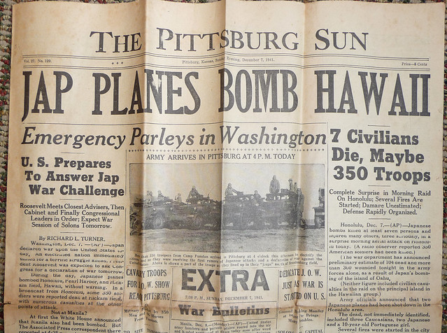
One of our graduate assistants came in recently with an old newspaper that her husband had found on a deconstruction job. Considering that it was, apparently, stored in a wall for decades, the December 7, 1941 Pittsburg Sun was in fairly good condition: brittle, but almost entirely intact and clear. I didn’t want to force the folds into a flatbed scanner – the paper clearly isn’t going to survive too much handling, and the next step is to show it to our archivist – so I took some pictures with my camera to share.
Interestingly, we got an email today indicating that the Governor has declared today a half-staff day, in honor of the anniversary, so consider this our contribution to the remembrance.
I have uploaded images of all four pages of the Extra edition in the Flickr set, as well as detail shots of some of the more interesting bits. My favorite bits, aside from the Japanese Consul General in Hawaii’s attempt to deny the raid(!) are the maps on page 4, which were obviously prepped and ready to go, possibly previously run material that they reprinted.
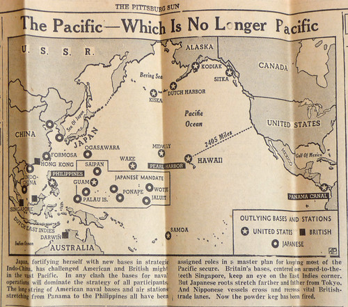 |
Map Heading: “The Pacific – Which is No Longer Pacific”
Map shows US, Pacific Ocean, East Asia and Australia, illustrating proximity of US outposts to Japanese mandate territories. Caption reads: “Japan, fortifying herself with new bases in strategic Indo-China, has challenged American and British might in the vast Pacific. In any clash the bases for naval operation will dominate the strategy of all participants. The long string of American naval bases and air stations stretching from Panama to the Philippines all have been assigned roles in a master plan for keeping most of the Pacific secure. Britain’s bases, centered on armed-to-the-teeth Singapore, keep an eye on the East Indies corner. But Japanese roots stretch farther and farther from Tokyo. And Nipponese vessels cross and recross vital British trade lanes. Now the powder keg has been fired.” |
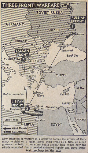 |
Map Heading: “Three-Front Warfare”
Map shows Germany, Russia, Balkans, Eastern Mediterranean including Libya and Egypt. Caption reads: “New outbreak of warfare in Yugoslavia forces the armies of Germany to fight on a much-feared third front at a time of allied pressure on both her other battle zones. Map shows how the widely separated fronts created extended supply and troop transport problems for the axis.” |
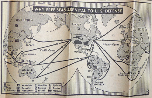 |
Map Heading: “Why Free Seas are vital to U.S. Defense”
Global map showing transportation lines from all continents. Labels include: Tin, Mica, Antimony, Vanadium, Tungsten, Manganese, Graphite, Chrome, Nickel, |
The whole paper is worth browsing through, and I haven’t had time, at this point in the semester, to do it justice. The main thing that I noticed is a great deal of war news: the coming of war is clearly surprising, but doesn’t seem shocking. The Washington Daybook, for example, which is about industrial and refugee diamonds, and the “Free Seas” maps above, not to mention the Jayhawk Ordinance Works dedication and the War Bonds cartoon, point to a substantial wartime footing already in place.