It seems to have gone pretty well. Of the 22 students who finished the class 14 did the survey about it (anonymous, but they got points for it) All of them claimed to have liked the assignment, and learned something from it, and, most importantly, to have learned things from other students presenting their research and from the group part of it.
The point of these assignments is for students to read some stuff, discuss it in their groups, present on it, and then (individually) write something based on their own reading and what their fellow students have presented.
I think there are a couple things to change in the future. There are two parts of the process that need fixed. Right now it goes
-Students pick a group of 1-3 people, and choose a set of readings.
-Students read their individual reading, write an analysis of it, and then discuss it with their group.
-The group writes a paper synthesizing the three readings, and does a presentation to the class on them
-I think I will get rid of the group paper. It is sort of the same thing as the presentation, and getting them to synthesize it once (for the presentation) is enough. It tends to be hard enough to push them towards synthesis of the three readings and why they matter, rather than just pasting the three reading papers together. Students tend to draw more from the presentations than from the group paper anyway.
-Students write an essay based on their own readings and the presentations of the other groups.
This is probably the biggest weakness. I try to write broad “questions” as topics for their essay, and then encourage them to narrow it down a bit. This is something that is difficult to do at the best of times. Maybe add a meeting with me to help with the question framing?
The other issue, of course, is how to do this for my other classes. The Republican period in Modern China, Taisho in Modern Japan and Huainanzi for Early China all fit nicely in the early/middle part of the class and lend themselves to questions about how this period (or at least some of the things going on it it). How to do this for my other two upper levels, Early Modern Japan and Late Imperial China? Those are both classes that focus more on social and cultural history, and don’t really have a clear middle bit that would work for this.
Maybe for Japan something like “Representation and reality” focusing on elites and the reading public tried to understand and represent the society around them? For China maybe something on the shi as doctors to society? In other words, rather than something chronologically central, maybe more socially central?
While poking around for English language materials to offer students on post-1945 South Korea, I came across The New Spirit Movement, a 1979 collection of short speeches by Park Geun-hye (Pak Kŭnhye, Park Keun Hae), president from 2013-2017 and thereafter convicted and jailed until 2021 on charges of bribery and various abuses of power. I believe the work is an English language edition of 『새마음의 길』published in the same year.
Park was daughter of the Korean president and dictator Park Chung Hee, who took power following a 1961 military coup and ruled as president from 1962 until his assasination in October, 1979. Her mother was also killed in 1974, after which the daughter stepped into something of a first lady role. One of the roles that Park Gyeun-hye embraced was as one of the leaders of a “New Spirit Movement” (새마음운동, also translated as New Mind, New Heart and New Spirtual Movement) in the late 1970s, a “vague and ineffective” campaign to “reform the thinking pattern of people.”1
This vagueness can be seen throughout this collection of speeches. It reminded me of the kind of warm good feeling fluff I had seen in lots of materials of another more international movement, the Moral Re-Armament movement, as well as Chiang Kai-shek’s “New Life Movement” (新生活運動), an observation already made by David Steinberg in a 1982 review article.2
In another 1980 piece discussing the movement, Hans U. Luther quotes one informant as saying “Not two persons could provide a definition for [the New Spirit Movement] that they would agree” and two others: “To the young female clerk at the post office, Saemaum is a term she could not being to define. But if she is asked what she did for Saemaum, she can tell about the flowers she helped to plant around the post office a month or two ago. To the taxi driver the Saemaum program might mean not spitting out the window of his vehicle.”3
All About the 충효예 忠孝禮
So what does Park herself (or whoever composed the speeches) have to say about the movement in a book of some 130 pages (in the English version)?
Park giving a speech to students at a New Spirit Movement. On the wall behind her: 忠孝禮는 우리 마음의 거울 (ch’ung-hyo-ye are the mirror of our heart/spirit).
Without a doubt the keywords in this “new” movement is a move to cultivate “traditional” values, the most important of which are loyalty (ch’ung 충 忠), filial piety (hyo 효 孝) and propriety (ye 예 禮). Anyone familiar with the history of the region will recognize here three of the key Confucian virtues, but one of the things I found interesting about this campaign and speeches is that, unless I’m mistaken, there is not a single mentionof “Confucius”, “Confucianism”, or any specific Chinese classical text in the book. The closest it comes to this is, again vaguely, “The ways of chung, hyo and ye were expounded to the world by the sages of old” (120) and a mention of the Confucian scholar Yi Yul-gok (Yi I, 98). In contrast, a whole speech is dedicated to the compatability of the New Spirit Movement with Buddhism, as Park speaks to a hall of monks.
As the reader moves through one repetitive and vacuous speech on moral and spiritual reform to another, it becomes quickly clear that these three core concepts of loyalty, fillial piety, and propriety not only seriously overlap, but that they are such capacious concepts, that Park is able to fill them with almost anything.
Ch’ung is the key to an advanced nation, where “one can drink good coffee in any coffee shop” and ensuring that “when we make an appointment, the spirit of chung directs us to be there on time.” (17) Hyo (at level of family and nation) seems to be the only thing that can give humans purpose: “Suppose a schoolchild gets 100 marks in an examination but has no parents or family to whom he can brag about his performance. Suppose a sports champion wins in a world competition but has no fellow countrymen with whom he may rejoice and no fatherland to which he may bring back the glory. Then, what is the good of the triumph?” (39) As for Ye, “it is an act of propriety to answer respectfully the call of one’s parents and elders; it is an act of propriety to share food with a hungry person…keeping a promise is an act of propriety” (28).
Park doesn’t seem to be too bothered by the fact that care for one’s elders is sometimes filial piety and sometimes propriety; or keeping promises is sometimes about loyalty and sometimes propriety. In fact, in the speeches in the second half of the book, in the vast majority of cases, Park seems to give up disaggregating them entirely and merely refers to “chung, hyo and ye” or, sometimes, just the “new spirit” when she describes what virtue is manifest in an action. This new spirit calls on Koreans to suck it up and properly learn the honorifics of the Korean language. “Some say [they] are difficult to grasp. But I wonder if such people are not really shifting the blame from themselves to the language…If we are going to claim to be a cultured people, we should not expect everything to be simple.” (77), to behave yourself when in a foreign country (79, 87), stop pollution (91-93), and reprimand naughty children (56). Fairly often, she seems to get bored by the specificity of the examples entirely, and will roll out broad generalizations: “Our Campaign for a New Spirit impels us to reflect on and remedy all wrongs in all areas of our life.” (78)
Reading, or rather skimming, through these extremely repetitive speeches, one gets the impression you can tell more from the final lines of each speech that identify the audience Park is speaking to than anything else in them: ch’ung, hyo, and ye mostly become highly malleable containers for her to fill with whatever content best addresses whatever the message of the day is to a particular group.
Ironies and Aftermaths
In the relatively few places I have seen the 새마음 movement discussed, it has most often been connected as growing out of, or connecting to the much more famous “New Community Movement” (새마을운동). An interesting contrast can be seen between the New Spirit movement and Park Chung Hee’s publications on the New Community movement, such as in the English edition of Saemaul : Korea’s New Community Movement (1979) or his earlier musings in 1964 Our Nation’s path; Ideology of Social Reconstruction, with their relatively more concrete political program and, in the latter case, a negative assessment of the role of Confucianism on Korea’s past.
Unlike the more substantive debates on what was or was not an outcome of the New Community Movement, most of what I found in a cursory search doesn’t suggest that this campaign amounted to much more than some big gatherings to listen to Park Geun-hye and line up to meet her. I see Park was involved in a 새마음 hospital of some kind, though I don’t know what connections it has to the movement. One short piece suggests that the movement pops up again in a corporate setting in recent years.4
One irony of this moral reform movement is, of course, that rather than a paragon of moral virtue, Park came to personify corruption and the abuse of power. Her presidential record and the scandal that led to her eventual conviction has been explored in great depth by journalists, many of whom have looked back at her political career in the 1970s. Through our St Andrews library, I don’t have access to Korean academic databases to dive deeper into the scholarly literature on the campaign, but the most detailed exploration of the New Spirit movement and its contemporary political connections I came across comes in a 2015 Hankyoreh piece which explored the New Spirit Movement in connection with debates on textbook reforms: 2015년 ‘새역사 운동’ 뿌리는 1970년대 ‘새마음 운동’ (IA) together with this 2014 OhmyNews piece: 새마음운동으로 유신독재의 주역이 된 박근혜 (IA)
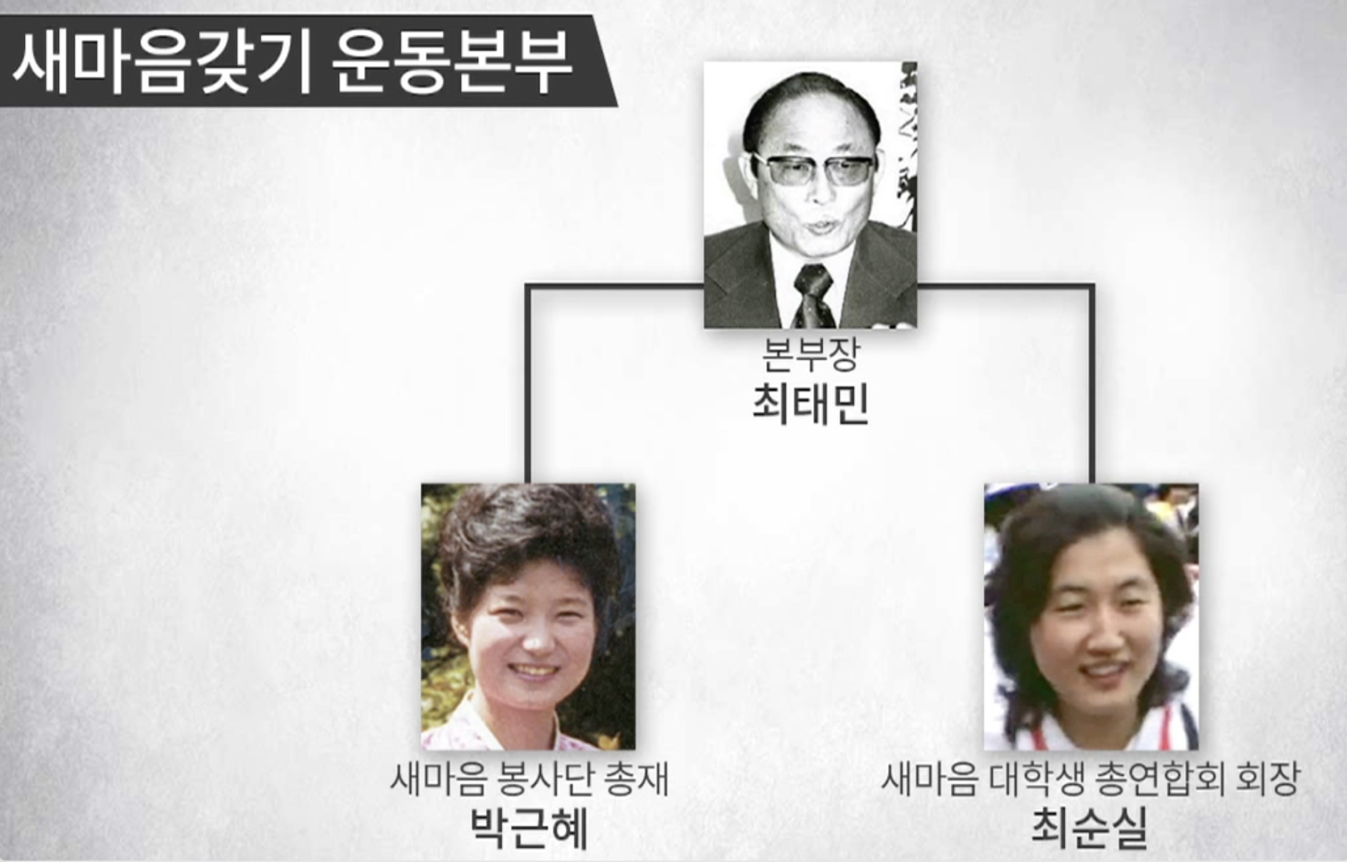
The more direct connection between this 1970s campaign and Park’s final years as president comes from the fact that a founding leader of the movement was the former colonial police officer and cult leader Ch’oi T’ae-min (최태민). Ch’oi had long exerted influence on Park, and, following Ch’oi’s death, his daughter, Ch’oe Sun-sil (최순실), who was also a leader in the movement, played the most central part in the scandal that brought Park’s downfall. This Korea Timesarticle (IA) claims that the New Spirit volunteer organisation (새마음 봉사단) was created by Ch’oi T’ae-min in 1975 when he renamed an earlier National Salvation religious organisation (구국선교단) was renamed. I’ve seen a lot of different claims floating around about what, in practice, all these various 새마음 organisations (a hospital, a school, university organisation, buddhist group, and factory laborers) actually did in practice, other than line up in large numbers to hear Park’s speeches, but I haven’t seen all the evidence lined up myself. At the very least, the movement was a clear early example of bringing together these three figures. There is some nice footage (including two of the screenshots included above) in this news clip, 뉴스타파 – 최순실+박근혜 ’40년 우정’ 동영상 발굴 (IA), showing Park and Ch’oi Sun-sil together at a New Spirit Movement event at Hanyang University with a cameo appearance from former president Yi Myŏng-pak (이명박 Lee Myung-bak), who was also convicted for corruption and abuse of power.
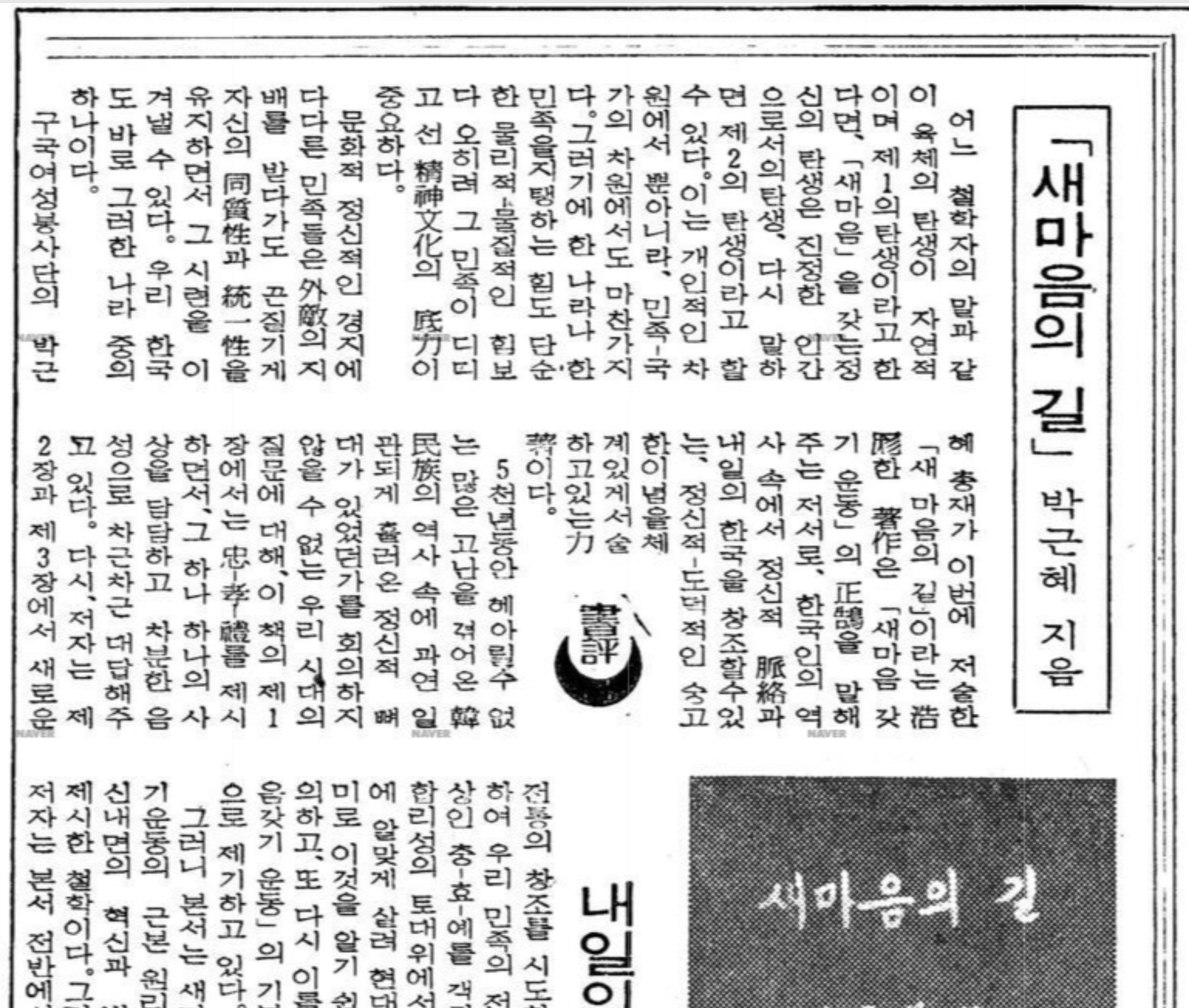
The same year as the Hanyang University event in the clip, and only a few months before her father’s assasination, Park’s collection of speeches 『새마음의 길』(The Way to a New Spirit) was published, which I assume is the same work as the very rapidly translated New Spirit Movement. The leading conservative daily newspaper Chosun Ilbo reviewed the work in March (1979.3.10 p5), gushing with praise:
저자의 문장은 세련되어있 다. 저자의 話法은 有情의 對話와 같다.
전혀 구호나 이데올로기의 선전은 없다.
The author’s style is refined. Their manner of speaking is that of a warmhearted conversation. The work is completely free of slogans or ideological propaganda.
In a way, I agree with this assessment. Relatively vacuous moral/spirital political campaigns such as the New Spirit Movement, Moral Re-Armament, New Life movements, etc., which thrived most in deeply anti-Communist contexts, as they yearned to generate enthusiasm for innocuous broad umbrella “Do good better best, like we used to, but in a fresh new way” campaigns. There were plenty of slogans in the campaign itself, seen on banners hanging all around Park when she gave these speeches, but like the speeches themselves, they had to be almost empty of meaningful concrete content that might generate controversy: the banality of moral reform campaigns seems here to be on full display.
Juergen Kleiner Korea: A Century of Change (2001), 157. ↩
David I. Steinberg, “Development Lessons from the Korean Experience–A Review Article,” The Journal of Asian Studies 42, no. 1 (1982): 95. ↩
Hans U. Luther “Government Campaigns in South Korea: Exorcism and Purification of Nature and People” Internationales Asienforum no. 1-2 (1980), 63. ↩
I’ve been watching Twitter not-so-slowly go into decline and it has made me reflect on how, increasingly over the last decade, I’ve been sharing fun sources by twitter thread than on the Frog in a Well blog here. I’ve since made the move to Mastodon (@konrad@coop.social) but for whatever reason, that new home seems like a better place to share links to blog entries instead than confusing threads with short posts. I’ve downloaded a backup of all my old tweets and thought I would start picking out some of the source related threads I’ve posted there to share again here in the form of blog posts.
This first post will share a series of images I came across back in May, 2021 while browsing the issues of the North Korean journal Hwalsal (활살)/Hwasal (화살) or “The Arrow”, which can be found in the wonderful Library of Congress digitized North Korean Serials collection. This publication (looks like Hwalsal 활살/弓矢 is a variant and was common in Hamgyŏng dialect, the journal switched to Hwasal in 1959) is full of political artwork and slogans, a few of which I have shared below.
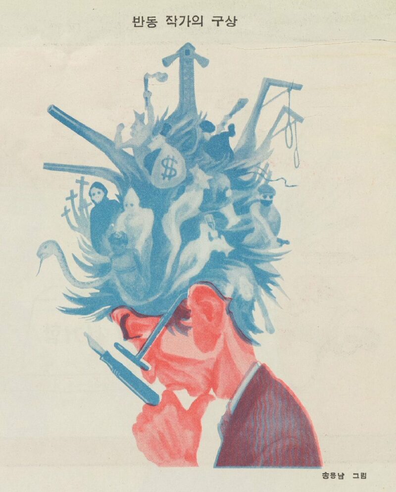
The reactionary author (활살 1956.5):
Taking out the paperwork-ist’s compost (활살 1957.3):
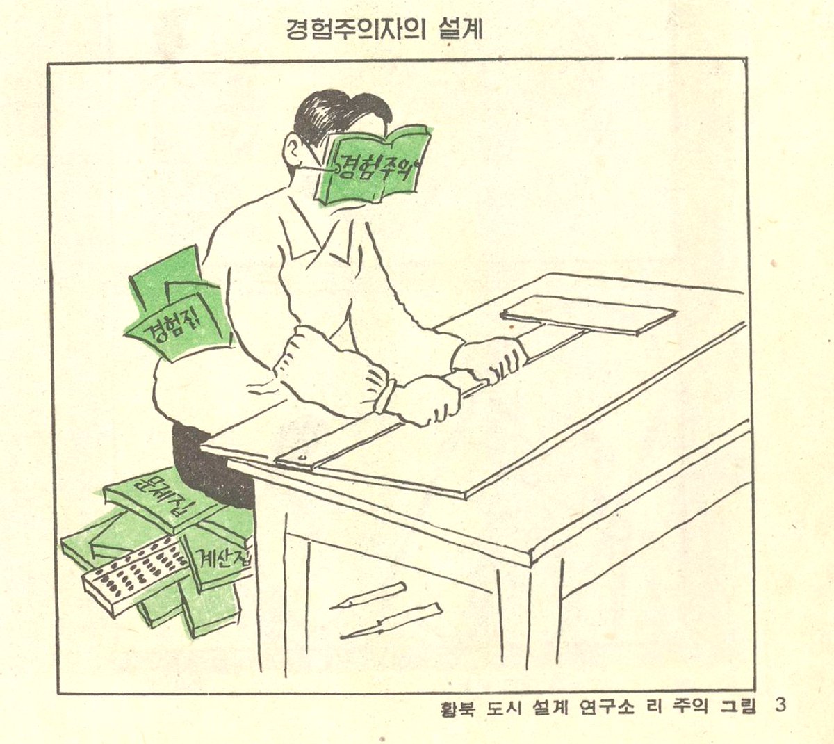
The blindness of the “Empiricist’s planning” (화살 1959.4):
The subjectivist puts together its agricultural plan (화살 1960.3):
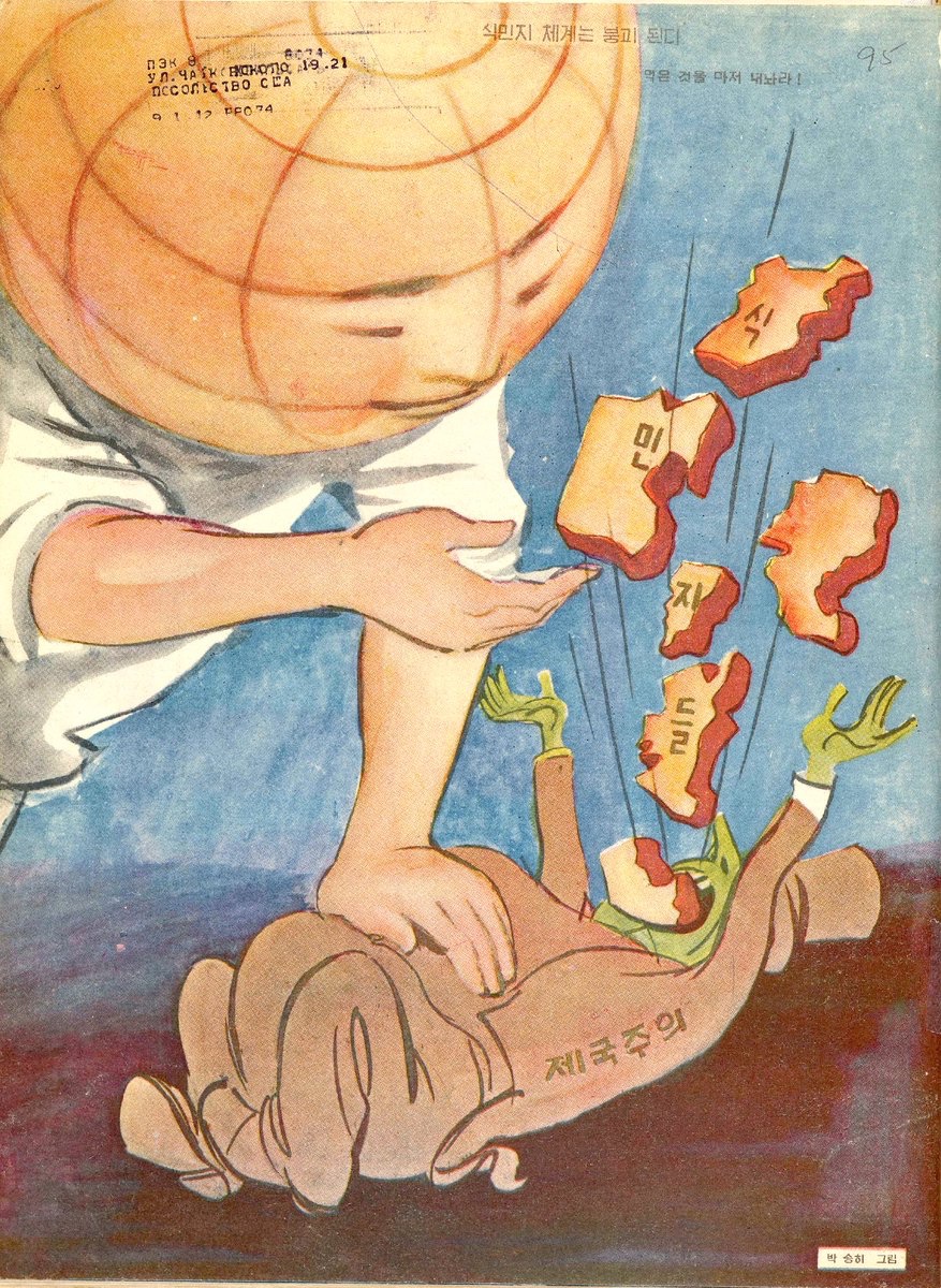
Making imperialism puke out its colonies (화살 1959.2):
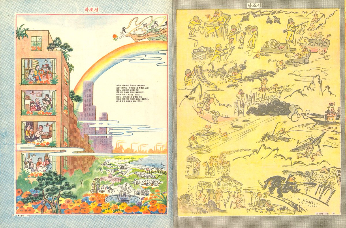
North and South Korea compared (화살 1961.9):
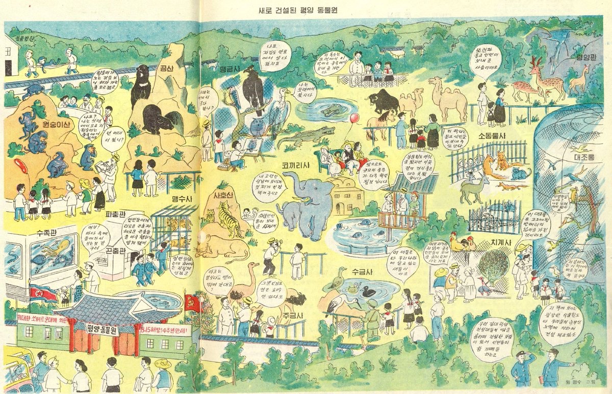
At the new Pyongyang zoo, the animals will tell you if they are gifts from the Soviet Union, China, or Mongolia (화살 1959.8):
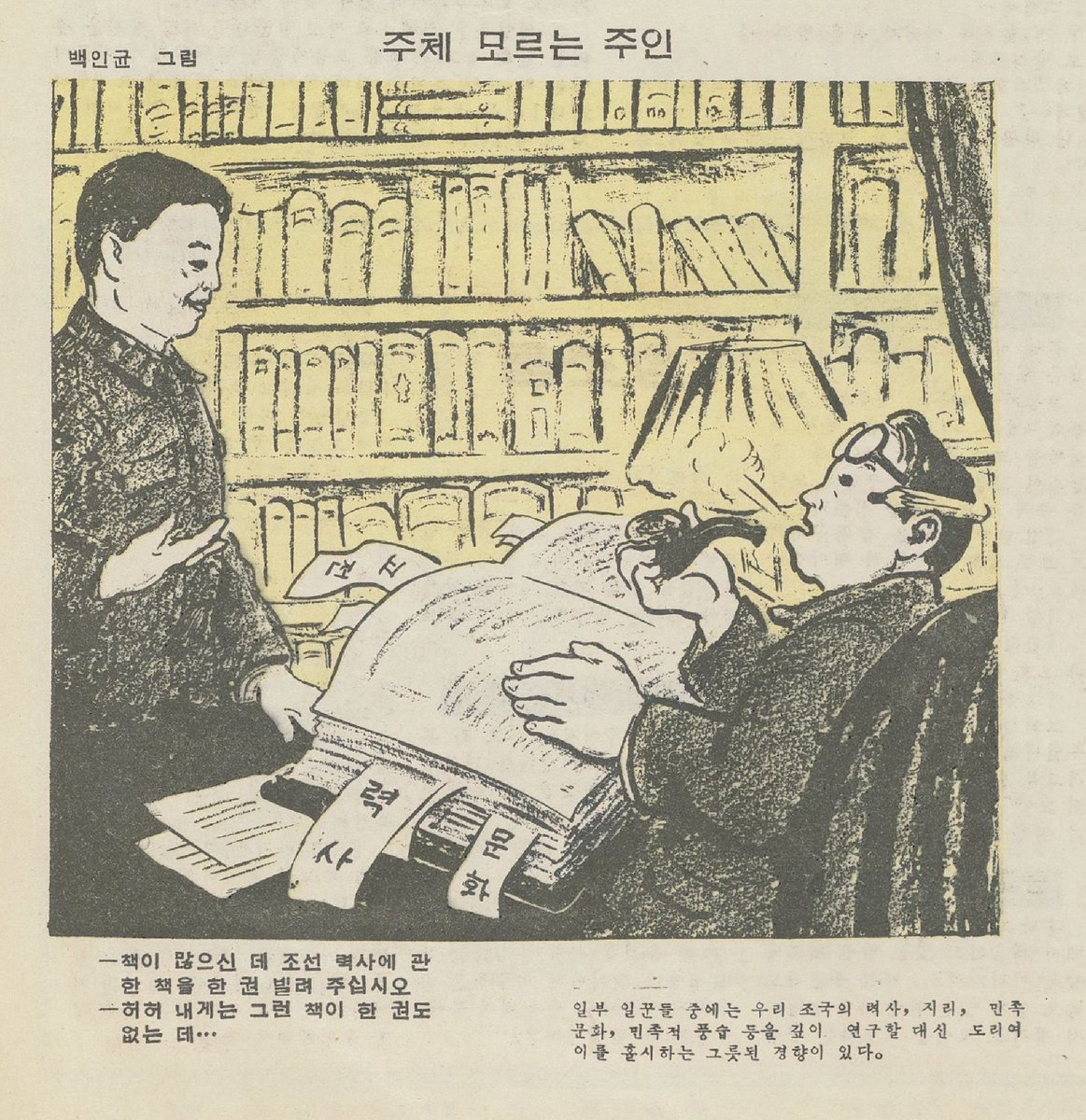
An employer who doesn’t understand the Juche ideology. All these books, and yet not a single volume on Korean history (활살 1956.4):
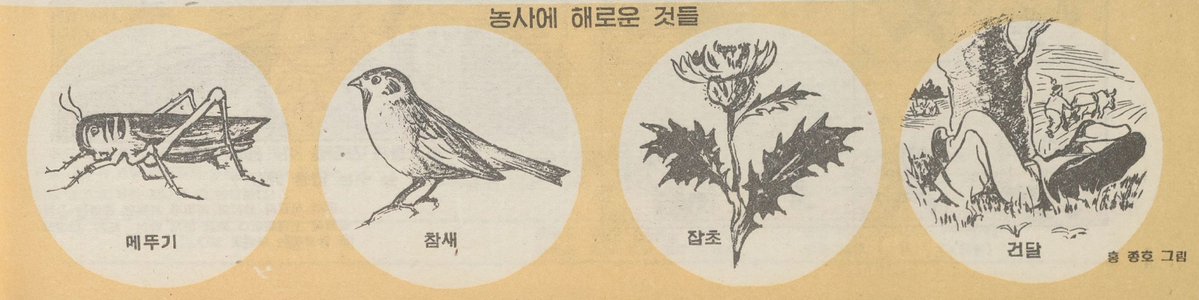
Things detrimental to agriculture: locusts, sparrows, weeds, and idlers (활살 1958.4):
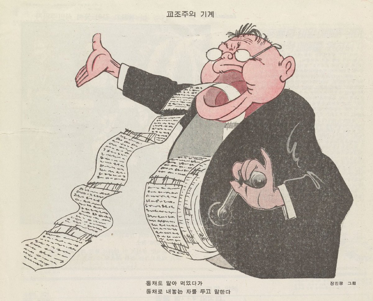
“The Dogmatism Machine” (활살 1956.5)
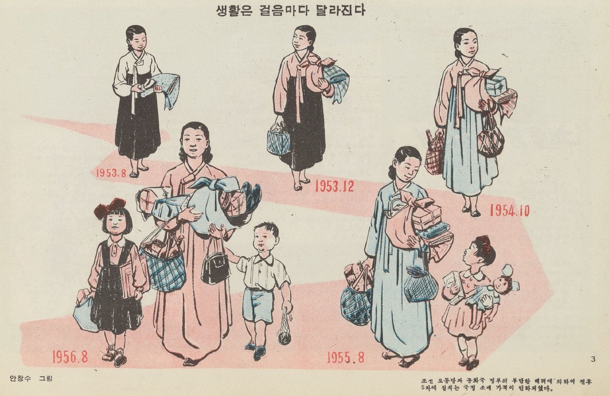
“Life changes with every step.” (활살 1956.2):
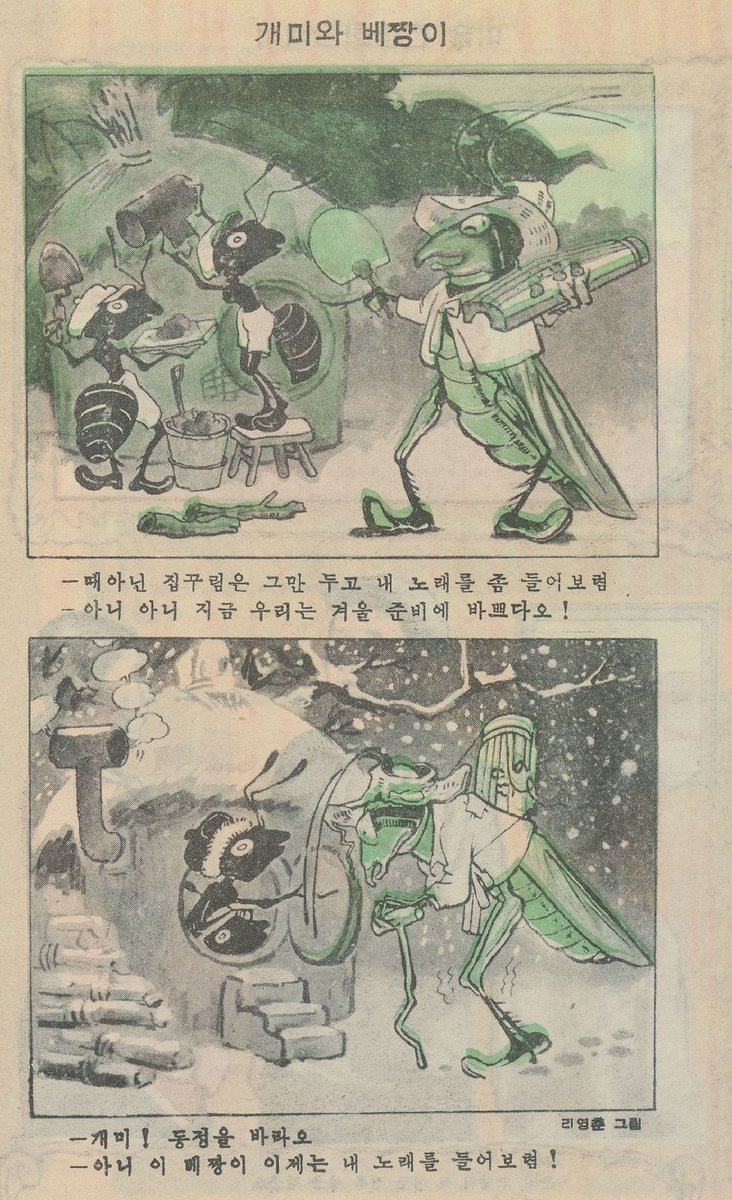
Aesop’s ant and the grasshopper fable put to work (활살 1955.9):
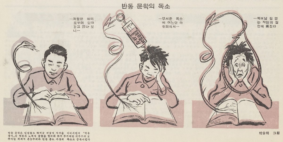
Beware the poisonous bourgeois thought found in reactionary literature (활살 1956.2):
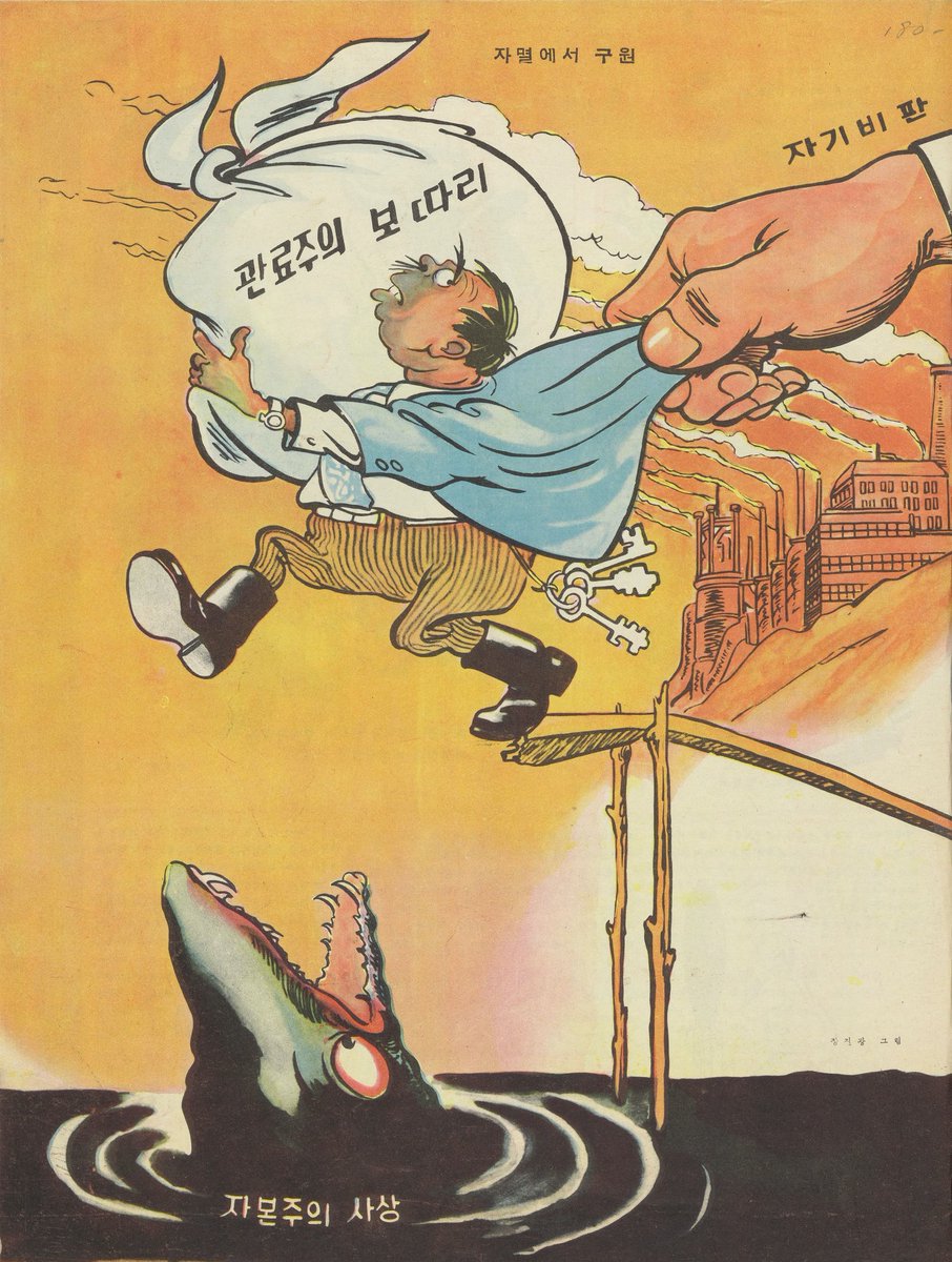
Self criticism will save you from carrying your bureaucratism bundle off the cliff into the jaws of capitalist thought. (활살 1955.5):
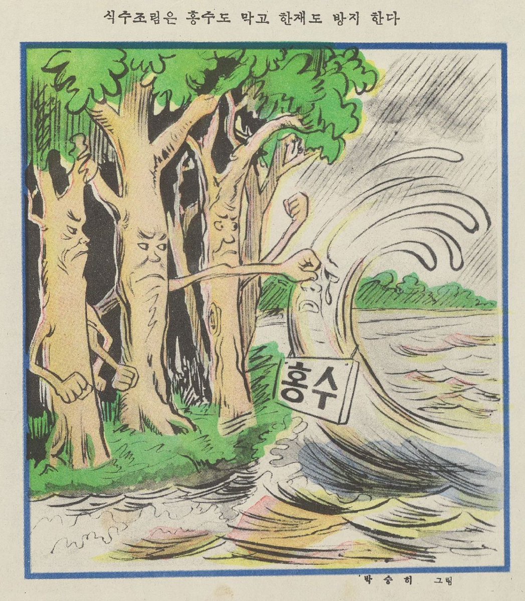
Stopping floods and drought by planting trees. (활살 1954.3):
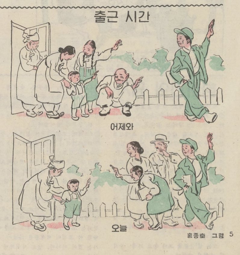
Heading to work. Yesterday vs today. (활살 1958.12):
Here is the semi-final list of topics for the group research project. So if you want a definitive list of all the things that were going on in Republican China… This is not it. More a list of things I came up with, but it does cover a lot of ground.
This Fall I will again be having students do a group research project. They will split into groups and read some articles and present on them and then write something based on what everyone has presented. (Some links to previous versions of this type of thing below).
Here is a draft of the project assignment, along with a start of a list of possible readings. Any advice about possible topis is welcome!
If you ever have to teach about the end of Maoism, Ai Qing‘s poem “On the Crest of a Wave” is a good thing to use. Ai was one of China’s best known modern poets, who was arrested and tortured by the GMD, (which is why he changed his surname from 蒋 to 艾) then wrote poetry in service of the war effort, then moved to Yan’an. He was purged in the 1957 Anti-Rightist Movement and spent the Cultural Revolution cleaning toilets. He was rehabilitated in 1979, and in 1985 French president François Mitterrand was made a Commander of the Order of Arts and Letters. Quite the career. He also had an interesting son, who’s work you can use later in the class.
This poem is good to use because it gives you the fervor of the CR, lots of campaign type language, the disgust with the results, and the continued loyalty to the party and the revolution. (Now with Zhou Enlai!). You would have to do a bit of background with them on the first Tiananmen Incident and the Fall of the Gang of Four, but the poem itself should not present huge problems.
On the Crest of a Wave
Written for Han Zhixiong and young friends
of his generation
I. “I Am Only Han Zhixiong”
Let me introduce you to the others:
“This is a hero.”
You laugh and protest:
“No hero. I’m only Han Zhixiong.”1
A self-seeking hero might prove embarrassing,
The people paid you their most glorious compliment –
Still, you could, quite without embarrassment,
Consider yourself the hero of “The Tiananmen Incident”.
When the wolves bared their teeth, flashed their claws,
Right away, you dared to go up and pluck their whiskers,
You were brave in the fight,
Enough to bolster the pride of a generation!
And you were clear-headed,
Like an island steadfast against wind and wave,
Under the blue dome of the sky,
Silently watching ten thousand waves ….
There is a pun in Chinese impossible to preserve in English. The Chinese for “hero” is yingxiong; Han’s name is Zhixiong, which means “will-to-be-a-hero” – Ed. ↩
So, the Huainanzi project in my early China class went ok, and would have worked better if I had been better at explaining what I wanted from the final paper. I did an anonymous survey and the students pretty much all claimed that they got something out of it, and the only complaints were about the massive workload (one) and that they procrastinated too much (many). They seem to have liked the group research project thing. To summarize, each group of 1-3 (they got to choose how big a group they wanted) had to present on one of the chapters in The Essential Huainanzi, and they were expected to also draw on the chapter in the full version. Then each student wrote a paper on the work as a whole, drawing on their own readings and what others presented.
As I said, it went ok, but the final papers would have been better if I had come up with a prompt that got them to focus more on specifics. The prompt was fairly general, and while I encourage them to limit it somehow, many of them did not, and I ended up with a lot of papers on “the meaning of the Way in HNZ” that did not dig much into the specifics of how the text explained things and made its points and were, as a result, pretty vague. I should have used this
… if we spoke exclusively of the Way, there would be nothing that is not contained in it. Nevertheless, only sages are capable of grasping its root and thereby knowing its branches. At this time, scholars lack the capabilities of sages, and if we do not provide them with detailed explanations,
then to the end of their days they will flounder in the midst of darkness without knowing the great awakening brought about by these writings luminous and brilliant techniques 21.3
They seem to have assumed that their reader was a sage, and I need to encourage them to dig more into the specifics of the text so that they could explain (and understand) things more clearly.
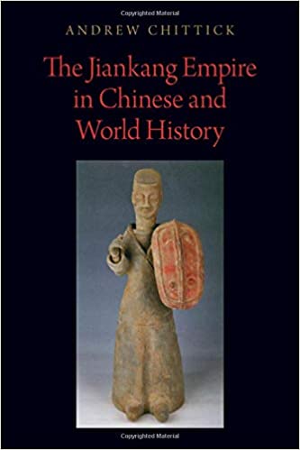
I don’t usually post book reviews here, and this is not really a book review, but I got a lot out of Andrew Chittick’s new book The Jiankang Empire in Chinese and World History. This is a book that integrates South China into Chinese history and world history by both emphasizing the unique and interesting aspects of Southern culture and systems and analyzing how some of the same categories used to explain Northern history and Southeast Asian history can be used to explain the South.
One of the things the book is good for is helping people like me, who don’t really know Early China, but have to teach it, to understand the South in the Age of Disunion. The whole Age of Disunion name is a problem, of course, and more modern treatments like Lewis or Holcombe call it the Age of Cosmopolitanism and talk about the diversity of Chinese culture during this period etc.
Chittick claims that
“the Jiankang Empire’s (his new term for all the Southern dynasties) military and political culture both are seen as a ‘dead end’ that did not obviously lead to any period of greater glory for the Chinese people, or have decisive impacts on later Chinese, much less world, history.” (pg 8)
Chittick is -not- saying that other scholars who work on the period are writing old-fashioned Chinese nationalist “5,000 years of pure Chinese culture” history, where the great Chinese culture assimilates all the detritus of Asia, and the whole period is just an embarrassing gap between Han and Tang. He -is- saying that almost all of these works focus on the North. He is talking about many of the same things as these other books. Things like the difficulty of defining Sinitc (Chinese) culture during this period, the problematic relationship between the court and great families, the role of Buddhism in creating a unified polity etc.
This things all happened in the south, although in different ways. For instance, the “ethnic” division in the South was between the Zhongren (people claiming decent from the central plains) and the Churen and Wuren. (These are all terms he seems to have coined) and he goes explains how these groups went through a process of “partial ethnogenesis” that explains a lot of Southern politics and culture.
To some extent this fits into the old literature on Northern and Southern culture, wen and wu, Chinese and barbarian etc. He points out that the Churen were just as martial as Northerners, and that the role of Sinic high culture and “Chinese” and “non-Chinese” language were important and problematic, just like in the North, although it played out differently
The local customs value vigor and strength, and produce many brave and courageous men; the people are practiced at warfare and esteem deceit and dishonesty. Seven out of ten leading households are very much this way; families that store armor and clasp swords all pour out of their houses. Due to this, transformation by humanity and righteousness will have no effect; regulation by law and punishment will not succeed. Thus it has routinely been a failed country.pg 168
When Generalissimo Wang Dun was young he used to have the reputation of being a country bumpkin, and his speech also sounded like that of Chu.(pg96)
[Chen] Bozhi did not know books. When he was sent to Jiang Province, when he got official documents, he would only offer his general consent. Sometimes his document clerk would read them to him in vernacular language, and seize decision-making from his boss.(pg. 97)
but he is not just trying to defend the manliness of the South, he is explaining how the same sorts of categories -worked- (and did not ) in the South.
Some things were uniquely Southern. He points out that the Jiankang empire really fits pretty well with Southeast Asian ideas of kingship, where the ruler’s position came from the charisma he gained from -personally- achieving great things, either in war or culture or ritual, rather than by inheriting status. Among other things, this explains why Southern rulers were so often overthrown by younger relatives who had served in the garrisons (with the warlike men of Chu) rather than being sequestered in the capitol.
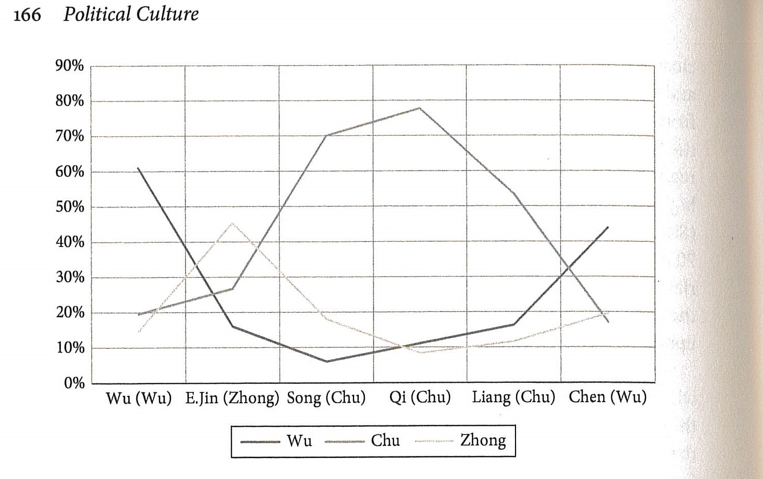
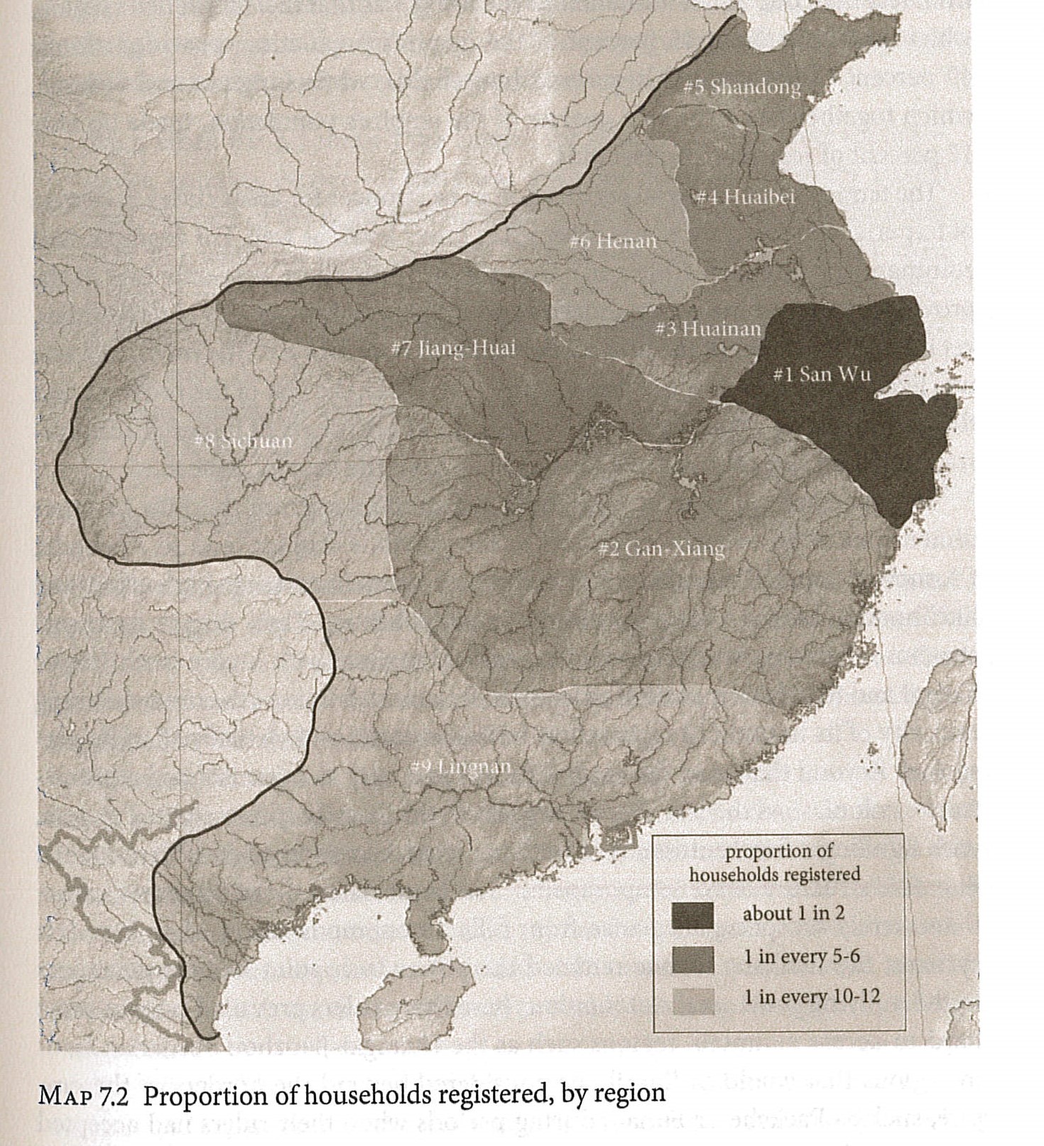
Some things are just better because he has done the legwork. Here, for instance, is his map of how much of the population was registered in different parts of the empire. This is based on his analysis in Appendix A, which I am not capable of critiquing, but the map makes a great visual if you want to talk about Jiankang as a regional state.
The only great weakness to the book is that it was published by Oxford University Press. Thus it is only in hardback, quite expensive, and not available on any of the (dwindling) number of databases my school subscribes to. Still, everyone who teaches this period, even in a survey, would get a lot of information and enjoyment out of reading this.
Works not really cited, but sort of handwaved at
Chittick, Andrew. The Jiankang Empire in Chinese and World History. New York, NY: Oxford University Press, 2020.
Holcombe, Charles. In the Shadow of the Han: Literati Thought and Society at the Beginning of the Southern Dynasties. Honolulu : University of Hawaii Press, 1994.
Lewis, Mark Edward. China between Empires: The Northern and Southern Dynasties. Cambridge, MA: Belknap, 2009.
Covid willing and the creek don’t rise we will start the semester in person four days from now.
One problem I always have will upper-level Asian history classes is getting majors to sign up for them. Not the Asian Studies majors, or the weirdos who like Asian history, the regular history majors. I have heard plenty of variations on “I can’t take your Modern China class. I don’t know anything about Chinese history.” My reaction is usually something along the lines of “Don’t believe what everyone says, you will actually learn something about Modern China in my class. Honest.”
This student attitude actually makes a lot of sense.
-We don’t have any Asian American students who would have a personal connection to this history (Coal strikes in Pennsylvania yes, China, no. )
-These are mostly topics they have never heard about in high school or World Civ in college.1 So there are not a lot of kids who want to know more about the Taiping rebellion or Taisho cafe waitresses because of what they learned before.
This last one is a real problem. A history class is a lot easier and better if you have some idea what might be coming next. In the past I have dealt with this by having them read the Modern Japan or whatever chapters from a World History text. This of course works better if you have them write something about the text, so this semester they will be pairing up and choosing terms from each of the chapters and then having them write short encyclopedia entries on two of the terms their partner selected. Ideally this should get them to engage with the text a bit and also learn something about the advantages and pitfalls of doing research via wikipedia (The place they should start) and how to go beyond that. We will see how it works, and I will ask them what they thought of the assignment afterwards.
Well, actually, that is how the death of the emperor was announced in the 1987 Bernardo Bertolucci film The Last Emperor, which came out just as I was starting graduate school. I spent a lot of time in front of students who wanted to know more about China because of that film. Wikipedia claims the film is based on Puyi’s autobiography, but really it owes a lot to Reginald Johnston’s memoirs. I am not much of a Reginald Johnston KCMG, CBE, (played by Peter O’Toole in the film) but Jonathan Spence CMG was.
That may sound like a put down, and that is sort of how his passing is being reported. The New York Times calls him a “noted China scholar” while the Washington Post calls him a “popular China scholar”. Ouch. A lot of the obituaries focus on his ‘textbook’ The Search For Modern China1 This makes sense because it was a big book (870 pages! Great research obit writers.) and one that a lot of journalists would have read in school. It is not really a textbook though, although it does sum him up pretty well.
I never met Spence, but the first book of his that I read was Ts’ao Yin and the Kang-hsi Emperor, the most traditional monograph he ever did. I read it because my first historiographical essay in graduate school was on the Ming-Qing transition. That is a topic that has almost vanished from historiography, but at the time the detailed study of an actual dynastic transition was a big topic. Ts’ao Yin really made an impression on me because it actually worked well as a monograph, in that it explained a lot about the exercise of power in the period, yet it was also a very personal book about two people and their relationship. I still remember the bit from Spence’s Emperor of China where the Kang-hsi emperor is old and complaining (in a rescript, I think) that the officials who helped him build up the empire were now retired and writing poetry in their gardens while he was still getting up at dawn to read reports. That is exactly the sort of personal, almost novelistic thing that Spence would point out that made him less of part of the academic conversation. At the time it had a real impression on me as an example of how to get sources to tell you things that they did not want to tell you.
Saying that Spence was not part of the academic conversation requires a few caveats. He taught at Yale, which makes him an academic, trained graduate students, (in both Qing and 20th century, very old-fashioned) and was president of the AHA. His work was not, however in the form of monographs or really responding to a lot of what was going on in the field. Death of Woman Wang works well as a teaching book, and maybe Treason by the Book, but things like The Question of Hu or even The Chan’s Great Continent are not the type of things that the scholarly world produces or uses. I recall Spence pretty much owning the China part of the New York Review of Books for a long time, which sort of sums up where he stood, the ambassador between China Studies and the wider literate world.
Search for Modern China sort of exemplifies this. It is not a textbook. No sidebars. No study questions. Not broken up into neat sections. It is almost like a written version of an entertaining and enlightening class taught by a good teacher, which is how it originated as I understand it. I have taught with it, and it both worked well in that it was one of the only textbooks students would ever just read, and poorly, in that it was hard for them to dive into it and find things (which is part of what textbooks are for). I think it owes quite a bit to Gate of Heavenly Peace, which his book on Chinese intellectuals and revolution. There is a lot more to revolution than intellectuals of course, but the book is Spence’s take on it. Like almost everything he did it is about his personal encounter with a China that fascinated him. Like Reginald Johnston, really.
After a few links it all turns into German and Portuguese and Italian notices. Scholars apparently don’t get much attention in the American press. ↩
I thought it went pretty well, although there are some things I need to work on.
I had the students do a survey about it, and most of them found it helpful, and other than a few complaints about the reading load they seemed to have liked it and claim to have learned something from it.
I was reasonably happy with what they ended up doing. All of them read some stuff, and all of them learned something. Almost all of them were able to at least summarize an academic article.
In general, I need to do more to help them with synthesis and analysis. They mostly did fine with the chapter/article summaries, but had more problems with the group papers and final papers. The group papers tended to be summaries of the three articles/chapters they read rather than much of a synthesis or analysis. This was a common complaint from students about the oral presentations as well. They tended to do better when they were asked about things (usually by me) after their oral presentations. In general, they seem to have only started thinking beyond summarizing a reading when they got to writing their own papers.
-So maybe the solution is to meet with the groups after they have done their readings and before they do their group papers? Admittedly that may be a small window. Maybe meet with individuals after they have done their individual articles?
-They chose their topics from a large group of possibilities To some extent I lucked out on topics, since they all picked things that went together well so the group presentations seemed related. (Military, Police, Radical Right, Technology for the nation, Colonial Korea, Taisho Democracy, Great Depression, Religion and Drugs.) You may notice a bit a skew towards the “right” and the state here. Consumerism group did their best, and I did a sample presentation on café waitresses, but the cultural side of Taisho ended up a bit left out.
-I think the prompt for the final essay mattered a lot. That is the target, and they will fixate on it. McClain helped by giving me something from the text that was both broad and steered them a bit, but maybe I could do better.
-Oral presentations should be about 10 minutes each. That is about where they all ended up in any case.
-I had a set of “big picture” articles that I shoved to the end of the list, in hopes nobody would pick them as their topic. I had considered having everyone read them, but that would have been way too much reading. I did recommend them when a few students asked, and they seemed to help
In general I think the idea of trying to do a sort of distributed research project, i.e. setting up the scaffolding so that undergraduates can sort of do a joint research thing like grad students in a seminar is one that can work. Taisho is a topic that works well for this, since it fits right into the middle of the class, comes after a clearly defined period (we did a book on Meiji) and before the rise of ultra-militarism. I supposed the Nanjing Decade in Modern China, amd Han and the Outcome of Classical Chinese Philosophy in Early China could sort of work for this. Less sure on how to do it in the Early Modern China and Japan classes.
You would probably not think of Reddit as the best place to go for historical knowledge. For those of you who don’t know it, Reddit is the place where anyone can discuss anything. There are sub-reddits on Disney Princesses, and on Toledo Ohio. More relevant to this blog, there are also 20 subreddits on 触手強姦
Ask Historians has more rigid standards about what they will post as questions and answers than most of reddit, and they also have 1.4 million readers. They call themselves “The Portal for Public History”, which is bothersome, since it gives the impression that they don’t know what Public History is.
It is a great place to find out what The Plain People of the Internet want to know about the past.
So today we have questions about sexy ninjas
Were kunoichis/ female ninjas in ancient japan actually trained to kill their target by seduction and wearing revealing clothes and get their guard down, using hidden weapons, or is it just another women on the battlefield trope by movies?
but also broad comparative things that are really hard to answer, but that people like to ask
Why didn’t the Mongolian language spread as a prestige language in the Mongol Empire like Latin & Arabic did in their respective empires?
or questions like
According to the Pew Research center, 29% of South Koreans identify as Christians. Why were Christian missionaries so successful at converting people in South Korea, whereas they experienced far less success in other East and Southeast Asian countries?
One nice about the site that in many cases the questions will just not be answered. If nobody can come up with a good answer based on solid sources to a question like “Who would win in a battle between Alexander the Great and Oda Nobunaga” then the question just sits there.
The other nice thing is that in many cases they will just point people to answers to the same question that have been given before. They have FAQs for Frequently Asked Questions. Also for Very Frequently Asked Questions.
Looking through these gives you a probably not very surprising view of what people want to know about history. Are you surprised that in the Japan section there are a lot of perennial questions about samurai warfare? Or that Korean history begins with the Korean War?
On the other hand, there are a lot of really good questions and answers that are both worth reading and worth pointing students to so that you don’t have to write long e-mails on
As in the past, I need to order books for classes, and more generally think about what I will be doing next semester, so as always I am posting here. Posting these things forces me to think about what I am going to do, gives students who google a chance to drop the class, and lets me benefit from your advice.
I am teaching three classes in the Spring (Being Asian Studies coordinator gets me out of one.) HIST 198 (Rise of Modern Asia) HIST 332 (Early China) and ASIA 200 (Introduction to Asian Studies) I will do these in reverse order of complexity.
ASIA 200 is always the most fun to teach, and the hardest to figure out. The basic idea of the class is to introduce students to different parts of Asia and different disciplinary approaches. So there are a bunch of units built around a book about China/Anthropology, Japan/Film, etc. If you are really interested in this I did a presentation on this, and you can see part of it here (recording started a bit late).
This class will run pretty much the same way it always has. They will be recording their movie presentations, so the only one who has to sit through all of them is me. The units (for now are)
China/Philosophy Nylan, Michael. The Chinese Pleasure Book. New York: Zone Books, 2018. This worked great last time, so I will use it again. Of course it may have been because last time was the first Covid Spring, and students were in their rooms with nothing to do but read, but still, it was a good book that they got a lot out of. We used Perusall for discussion and this was the one time I got that to work. I think this book works well because it does what the students want (Help them think about themselves, give them the Wisdom of the East) and also does what I want, which is teach them something about Asia.
Journalism is always the first unit, since it makes a nice transition from general reading to more serious reading. I would be open to something else here, but this seems like the best recent book on Afghanistan before it vanishes from the public eye entirely, if it has not already.
I was going to do this because it is a good book, and also because I could pair it up with some of her other writings so they can get both the ethnography version and the “academic” version. Also I need a Korea book because a lot of our students take Korean, and this unit will be some of the only non-language Korea content they get. Available cheap as paperback, which also helps. In theory anthropology is the one discipline I could drop, since they are likely to do other classes on Asian anthropology. On the other hand, if you want good, accessible books on Asian culture…Anthro has a lot.
Japan/Literature Shusei, Tokuda. Rough Living. Translated by Richard Torrance. Honolulu: University of Hawaii Press, 2001.
I always do a literature unit in part because our school offers almost no classes that deal with Asian literature, and because this is a type of reading they are somewhat used to. Also, I can sneak some history in. This may end up being too close to Kendal in theme, but other than than it seems perfect. Tanizaki’s Naomi might work here, but some of the people who did that in History of East Asia may still be around.
History/Asia Perdue, Peter C., Helen F. Siu, Heidi Walcher, Victor Lieberman, Nancy Um, Charles J. Wheeler, Kerry Ward, et al. Asia Inside Out: Changing Times. Harvard University Press, 2015.
f I did a fifth book there might be an open revolt, so maybe have them each pick something and do some sort of semi-group project base on the Asia Inside Out books. I am still sort of unsure about this, but in that this gets me away from the national straitjacket, and away from the “read a book and discuss/ write a paper about it” model. This struck me as the most obvious collection to use for some sort of group project , although maybe there are others?
Then the same film unit I always do.
HIST 332 Early China
A class I always like (well I like all of them) but that does not always fill up. This one has become pretty fixed. Start with
Which does a good job of linking up and making sense of a lot of the early political history. (Also, since I am going to steal so much of the rest of the class from his other books it makes sense to have them get some of it right.)
Then
Huainan, An Li King of. The Essential Huainanzi. Translated by John Major, Sarah Queen, Andrew Seth Meyer, and Harold Roth. New York: Columbia University Press, 2012.
Since the library database has the full edition, and you can do all your philosophy and have them do some sort of project.
Then the hard part. What do to with the Age of Disunion/Tang? One problem with all of Early China is that a lot of the stuff is pretty technical, and thus hard to find cheap paperback copies of and hard for students to get into. I have had luck with Teiser’s Ghost Festival book, very little luck with anything else. This time I thought I would try
since this gives you both a bunch of politics and religion and other things. Any other suggestions?
HIST 198 Rise of Modern Asia The class for non-majors. This will be the same as in the past with
Ghosh, Amitav. The Glass Palace: A Novel. Random House Trade Paperbacks, 2002.
which they tend to like
and
Esherick, Joseph W. Ancestral Leaves: A Family Journey through Chinese History. First edition. Berkeley: University of California Press, 2011.
which should pair well with it. They are both looking at a broad sweep of Asian history using the story of a family. In practice maybe half of them read Ghosh and far fewer read Esherick. I probably need to come up with some sort of short writing assignments for these. Most of our freshman can’t write an essay on one of these (or part of one of these) without a lot of scaffolding that I don’t have time for. Any advice on what type of short writing to try would be most welcome.
Particularly as I work on the visual culture of aviation (one of my current projects) I am getting both encouraged and discouraged about the state of sources in the New Era. You can find all sorts of cool stuff, but often in unusable or unstable forms. (not a revelation, I know.) Two examples (not involving old photos of airplanes)
Here is a map I used in my Modern Japan class, showing the Boxer uprising (one of Japan’s first internationalist adventures)
I found it here https://weaponsandwarfare.com/2015/08/page/46/
via a google image search. Its a nice looking map, with a lot of information, and an impressive degree of specificity. The image says it is copyright Australian National University, but there the trail runs cold. I can’t find it via a google reverse image search (which seems to be getting worse over time), so if I wanted to publish it, or more likely trust it more when I teach about the Boxers in a China class, I am out of luck, unless I ask around on Facebook. More access, less solid sourcing.1
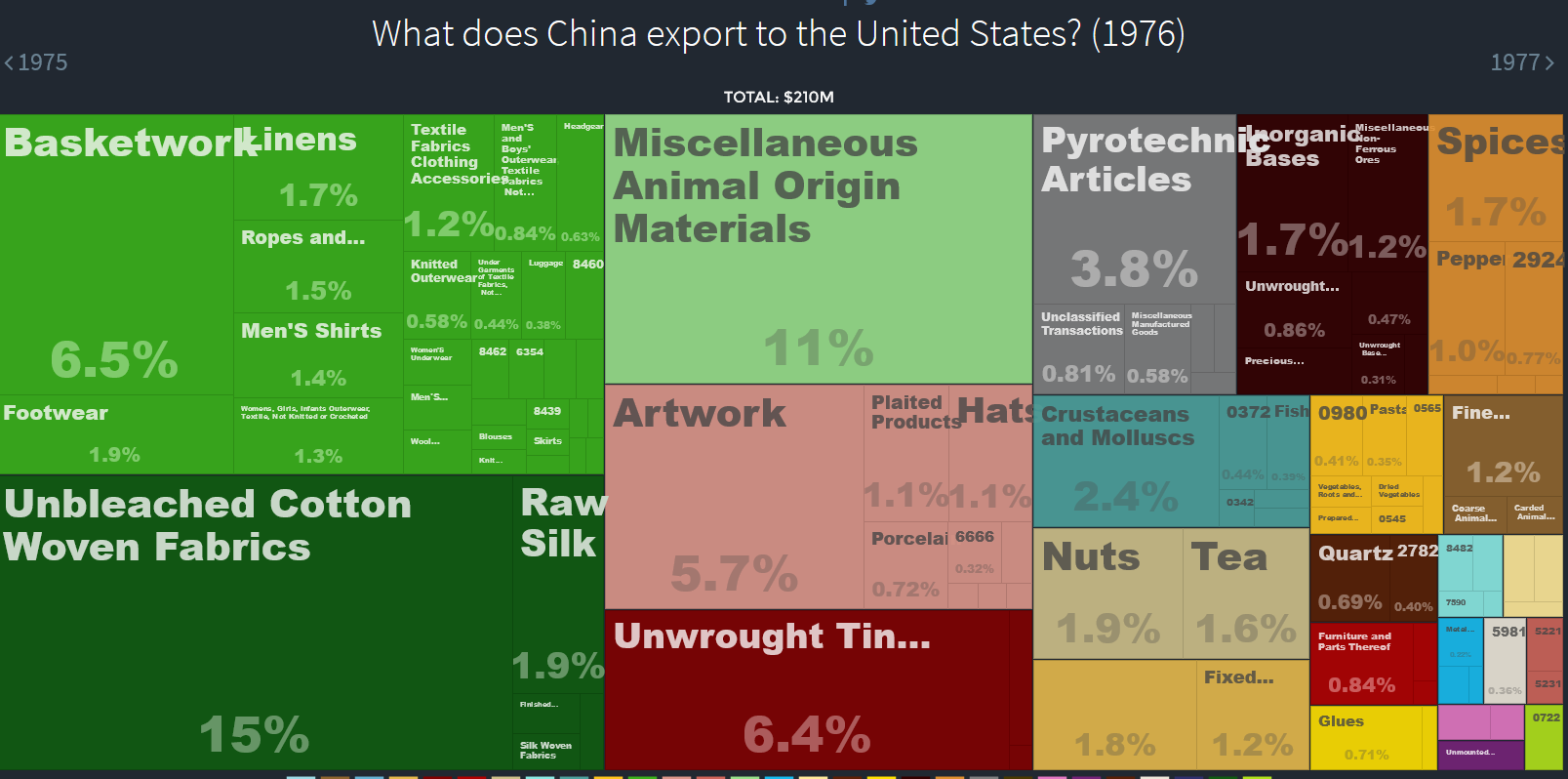
Here is another image, from this very blog, showing Chinese exports to the US in 1976.
the blog post (link below) discusses how you can use https://oec.world/ to generate images to talk about the changing trade relations between China and the U.S. Could I make up a similar set of images to talk about Japan- U.S. trade for this semester? Well I could have then, but the site is apparently now paywalled, has dropped a lot of the historical data and/or no longer updating. The print archive was never as stable as it promised, but the digital archive seems to be even worse.
I think the scholarly world is picking up on this a bit. I recently used an old Chinese cigarette ad. The citation I gave (and that the journal was fine with) was
Shanghai cigarette advertisement, Fuxin Tobacco Co., 1935.
This is an image that appears in many on-line and printed collections of Chinese
advertisements. A version of it can be found at <http://www.confuciusinstitute.
ac.uk/posters/> ↩
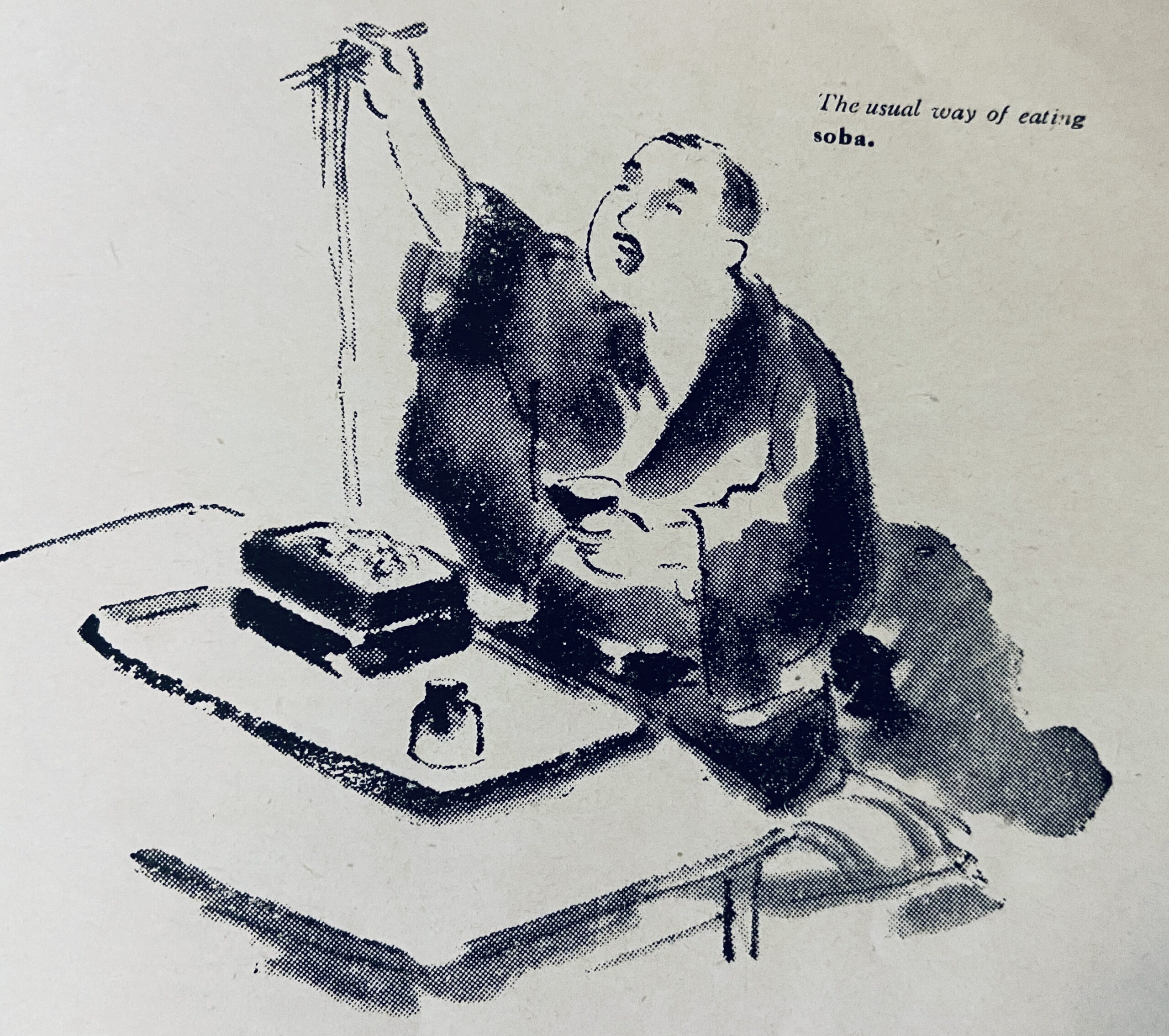
I picked up a cheap copy of an old 19461 tourist pamphlet Notes on Japanese Cuisine by Katsumata Senkichirō (勝俣銓吉郎). I’ve scanned my copy and uploaded it to the Internet Archive here.2 The pamphlet pops up in at least two recent works by Eric C. Rath: in his afterward to Devouring Japan: Global Perspectives on Japanese Culinary Identity and his new 2021 Oishii: The History of Sushi. In the latter, Rath highlights one of the points that also first struck me when skimming Notes on Japanese Cuisine the first time: that it celebrates sukiyaki as Japan’s ‘national dish’.3 “Sushi (Fancy Rice Balls)”, the last entry in the pamphlet, is introduced as the final boss to beat in the game:
Along the safe lines of approach are—sukiyaki, kabayaki, tempura, and soba. When these Japanese delicacies appreciable even to the exclusively European palate have been tried with success, the explorer is in a position to penetrate deeper from this borderland into the realm of the strange. What next? The voice of experience will whisper to him—sushi.
This is a fun little pamphlet to explore. Most of Katsumata’s extensive career of publications, including his 1901 collection and translation of humorous English language anecdotes to his role as editor of the 1954 edition of Kenkyūsha’s New Japanese-English Dictionary were related to English language learning and it is on show in the pleasant, if occasionaly hyperbolic, prose of the pamphlet, which offers a “rough charting of the sea of taste” in Japan. The rough waters are generated, at least in two sections, by the tension between “Tokyo” (Kantō) and “Kansai styles”4 of various dishes described, with those favouring the former sometimes given more voice their their claims to authenticity than the latter, e.g., “[the conclusion of those who favour the Tōkyō style of “sukiyaki”] is that the Kansai style may have fair claim to good economy, but that the Tōkyō style is the true way of a genuine lover of delicate taste…”5
The most passionate language in the pamphlet is found in the section on soba or “Buckwheat macaroni”, Japan’s “food for the people.”6 The crop of buckwheat itself is described as having “a queer destiny of receding before the advance of civilization,” shifting over time and “follow[ing the] Ainu in its northward retreat from developing culture” and ending up in the “backward provinces” on the “shady side of Hokkaido”7 This “retreat” north of buckwheat is given an unusual amount of space and at once replicates a standard narrative of combined civilizational progress and northern conquest, but then pivots to celebrate its use: praising its more “primitive” milling methods and its rich nutritional content, or highlighting its deep connection to the Japanese people. “A public bath and a soba shop are the earliest suppliers of wants that come into being in a developing Japanese community; so intimately is soba interwoven with our life.”8
Of the various foods discussed in the book, it is interesting to note that the only lines connecting Japanese cuisine to the world beyond the archipelago are found in the second to last paragraph of the pamphlet, concluding the section on sushi:
It is on record that the heroic Empress Jingū had sushi among the provisions for her expedition against Korea some seventeen centuries ago. Sushi in those old days, however, was preserved fish, or, rarely, meat, pickled not in vinegar but by preservation in salt for a long time. The original idea of the present form of sushi is said to have been brought from China by people who were sent out amity, commerce, or intellectual pursuits…9
See Eric Rath’s new work on the history of sushi for a more extensive discussion of these origin tales, but most interesting to me is that this was what Katsumata decided to go with for the conclusion of his pamphlet: a nod to Chinese connections. Was this part of a likely earlier 1935 edition of the pamphlet, or something new added in 1946, one might wonder. This is followed by the final sentence of the pamphlet, which doesn’t exactly leave one with the image of sushi as the pinnacle of refinement: “Sushi is now widely used for convenience of handling in garden parties, athletic meets, and picnics.”
Nothing in the pamphlet is said, of course, of the most fascinating transnational culinary characters in Japanese history. In 2016 I was invited by our university’s student-run Japan Society to give a short talk on the history of Japanese food. I protested that I was knew nothing about the history of food in general, and not much more on Japanese food history, in particular. No matter, they assured me, just come and tell us a few interesting things about your favorite Japanese foods, and in exchange they would prepare exmaples of these dishes for everyone to try. So I replied that I could offer some historical background notes associated with the first edibles I was introduced to by my host family on my first trip to Japan, when I spent a wonderful summer homestay volunteering at a kindergarten in the countryside outside of Tateyama, on the Bōsō peninsula in 1995: korokke (paired with something), ramen, and Japanese curry.
Clearly, my hosts correctly judged their new arrival as anything but ready to penetrate into “the realm of the strange”, but the “borderland” to that realm I was first exposed to was not the one Katsumata was referring to in the form of sukiyaki and soba, but rather the borderland between Japan and its historic culinary interlocutors. None of these three, which all have their origins outside of Japan, were likely to be what the students had in mind, but the latter two, ramen and curry especially, have particularly rich culinary histories in Japan, and are still my two favorite things to eat in Japan today. To be honest, and forgive this blasphemy, I would still choose a cheap but delicious bowl of udon or soba with a nice crispy korokke, consumed standing (立食い) on the platform of some station over the most delicious sushi in Japan. Platform noodles were apparently already common when Katsumata wrote his pamphlet in the 1930s or 1946: he refers to “station buffets” that sell soba to passengers who “desire to snatch a quick lunch during the short stay of their train at the station”. My preference for a bowl of noodles and a potato croquette is obviously revealing: it is not you, sushi, it’s me! It is just the kind of carbs with carbs definitely-not-slow-food barbarian I was raised to be, taking my meals through life as I change trains from one task to another.
A work by the same title, with Japan Travel Bureau as the author, is listed in the Japan, the New Official Guide (1941) p832 as a work published in 1935, which overlaps the period when Katzumata was, acccording to an autobiographical article (「私の歩んだ道」) by him, writing essays for the JTB. If a copy of the earlier 1930s edition is out there, it would be interesting to see what didn’t pass the SCAP censors for publication in a Japan under US occupation in 1946. ↩
A book I have been reading for fun this summer is Tim Harper Underground Asia: Global Revolutionaries and the Assault on Empire. It is a history of the various interconnected radical movements that tried to liberate India, Vietnam, Indonesia, China, etc in the early Twentieth century and how these people met up in Shanghai, Vancouver, Paris, Berlin, Batavia, etc and were tracked and manipulated by the governments of Britain, Japan, the U.S. etc. Here is a sample.
In May 1916 a Rumanian dentist called Max Kindler, who had arrived in Shanghai via Alexandria, Madras and Singapore -where he was wanted for ‘cheating’- came forward to inform on Ettinger. [Ettinger was previously identified as a “Yiddish-speaking Turkish subject under German protection”.] Short of money, Kindler had got caught up in the passport forgery racket. Here he picked up word, from an unnamed Greek, of a plot by Koreans -who were becoming the connecting tissue of many of these underground networks. They planned to raid an ammunition store and blow up the railway between Harbin and Vladivostok in return for German assistance in their struggle against Japan.1
It is a wonderful conglomeration of a book. I say conglomeration in part because it is mostly based on secondary sources but also, as the above quote sort of shows, it does tend to ramble a bit. There are certain themes he comes back to, like the growing state efforts to control free movement, but Harper is not making much effort to shove all this history into a 250 page monograph on Radical Asia. Instead we get a 600 page narrative that tries to follow all these people and groups through their activities, wanderings, love affairs, and prison terms. Later groups like the Comintern would try to organize and rationalize all this, but one of the points of the story is that these people (rebels, con artists, romantics, students, informers and lost souls, sometimes all at once) don’t fit well into any categories. A tighter book would not have room for discussion of historiography.
This is from the court’s condemnation of Bhai Parmanand in the aftermath of the Lahore Conspiracy Case of 1915. Even the government’s informers agreed that he was not involved in the conspiracy. He had been arrested in 1909, however, in possession of the manuscript of his never-published History of India. This radical document, (researched in the British Library Reading Room), was enough to get him condemned to death. (Later commuted to transportation to the Andaman Islands). I think it is the longest quote in the book.
No doubt a historian enjoys certain privileges. Criticism, exposure and condemnation of what is wicked or unethical; approbation of what is noble and chivalrous; and vindication of the truth are some of the privileges universally conceded to him; but he has no right, under the guise of a historical treatise, to malign, traduce, or calumniate anybody; much less a ruling race, with the object of bringing the subject of his criticism into hatred and contempt, which as a citizen owing allegiance to a Government, he has no rights to assail. He may point out the demerits of a Government, or of a race, or of an individual; but if a historian takes up only the dark side, and studiously avoids all mention or does not even hint of any merit of the subject of his criticism, he is not a historian but a man who abuses his privileges and renders himself accountable to Government and the public.
Now there are times and times. In times of peace a dispassionate condemnation of a people or persons, albeit they be rulers or Kings, cannot be impugned; but to take up old things long buried and forgotten except in books, and to impress upon the subjects of a Government that it is an evil worth ridding themselves of is nothing short of sedition clothed in an ostensible historical treatise. Mutilation and distortions may be forgiven a historian, few are free from this fault; bias may be excused as human fragility; but perversion with a sinister motive cannot be forgiven.2