
I think we need a new word for the study of colonialism, imperialism and the post-colonial discourses, pro and con. Pro? Who’s in favor of it? Well, this is what makes it interesting, these days: there are a lot of former colonial powers out there whose citizens and leaders, in their heart of hearts, still believe that they accomplished something that was ultimately positive, who still believe that their developmental initiatives and their anti-communist (or anti-capitalist) positions were justified by subsequent developments. This is usually — explicitly or implicitly — intended to mitigate or cancel out any discussions of political repression, economic exploitation, military atrocities or strategic abandonment. Sometimes it’s just good historical sense, but then it usually comes with very careful caveats about not canceling out the other stuff.
Academia/Books and Articles/China-Japan/Current/Recent Events/English/International Affairs/Japan/Memory/Nationalism/Politics/昭和
Colonialogy
I think we need a new word for the study of colonialism, imperialism and the post-colonial discourses, pro and con. Pro? Who’s in favor of it? Well, this is what makes it interesting, these days: there are a lot of former colonial powers out there whose citizens and leaders, in their heart of hearts, still believe that they accomplished something that was ultimately positive, who still believe that their developmental initiatives and their anti-communist (or anti-capitalist) positions were justified by subsequent developments. This is usually — explicitly or implicitly — intended to mitigate or cancel out any discussions of political repression, economic exploitation, military atrocities or strategic abandonment. Sometimes it’s just good historical sense, but then it usually comes with very careful caveats about not canceling out the other stuff.
CFP: Graduate Students’ Convention in Prague
I expect a lot of people will have seen this call for papers from Charles University in Prague already, but I’m reproducing it here in case you haven’t. It looks like it will be a great conference.
______________________________________________________________
ORIENTAL INSTITUTE – in cooperation with Korea Foundation; Charles University in Prague, Faculty of Philosophy and Arts, Institute of East Asian Studies, Seminar for Korean studies; Palacký University in Olomouc, Philosophical Faculty, Department of Asian Studies, and Czech-Korean Society – is pleased to announce:
CALL FOR PAPERS for the
KOREAN STUDIES GRADUATE STUDENTS CONVENTION
September 2006 in the Czech Republic.
The Korean Studies Graduate Students Convention (KSGSC) is an international conference for young researchers and students working on topics related to Korea organised by leading Korean studies institutes in Europe. The third KSGSC is planned for September this year and will be organised in the “heart of Europe” by the Oriental Institute, a top Asia-related research institution in the Czech Republic, in cooperation with other Korean studies institutions.
Continue reading →
AHA Panel Proposal
Hello everyone
I am trying to put together a panel for the AHA next year. I am interested in the construction of modern womanhood in early 20th century culture in East and Southeast Asia. This panel could also include comparative papers from other geographical areas. If any Frog in a Well readers would be interested in contributing, please email me
Katrina
Nomads and China
As the final installment in our exciting series of syllabus posts I present my last class for the semester, Nomadic Empires and China It is a topics class, so it is supposed to get our majors to do more focused historical work (the bulk of our upper-divisions are surveys, Modern Japan, Modern Italy, Colonial America, etc.) It is also supposed to get them to do some research. As I am already teaching it and may never teach it again I welcome any sort of comments but particularly any on things to watch out for/change for this semester.
The only really interesting thing about the syllabus is how new it is. A lot of work has been done on these topics in the last 20 years or so, and as a result the class is almost entirely different than it would have been had I taken it as an undergrad. That’s one of the reasons I picked it, of course. Lots of cool stuff and much of it in paperback. The Mote book is turning out to be particularly helpful. 80% of them bought it, even though it was optional.
Taiwanese Heroin
It has been rainy rather than snowy around here of late, which is very unusual for this time of year. While walking in a cold wet rain I began to try and think of something that would make me feel better. Something that was cheap, would make me feel warm, and ideally make me spit horrible blood-red spit. Sadly the only thing that does that is betel nut, and you can’t get it in Pennsylvania.

Thinking about Taiwan and betel nut led me to do a bit of research that turned out to be pretty surprising.
Continue reading →
Asia on the move
As we have been posting syllabi and asking for comments I thought I would do something radical and post one for a class that I will not be teaching until next Fall, in hopes of getting comments in time to do something about them.
The class is ASIA 200 the intro class for our Asian Studies minors. This will be the first time it has been taught, so I am not really sure how it will work out. We introduced it in part because Latin American Studies and Pan-African Studies have intro classes, but we don’t, and we figure that it will bring the students together. 1
The class is supposed to introduce as many parts of Asia as possible, and as many disciplinary approaches as possible. I organized it around a general theme of travel. The theme, of course, does not really matter, it’s just something to hang the course on. A lot of this is stuff that I am not really all that familiar with. What I wanted to do was find a range of interesting teachable things. I am really looking forward to the class, since one of the frustrations of this job is that I often read or see interesting things, but then I have no venue to teach about them. Now, with a bit of creativity, I do. Any advice about any of these topics, other better ways to do things, better sources etc. is very welcome. Continue reading →
History, or politics by other means
I would like to share my musings and solicit opinions on one issue I always was interested in – namely, to what degree the ways in which states attempt to rule over the past and use it for forming a suitable present, are effective, and on what factors their effectivity depends. To illustrate what I mean, let us just look what the “history” in the public realm meant in South Korea in Yusin time in the 1970s, and what sort of “history” is being mass-produced and encouraged currently. In the 1970s, in the official discourse on history the catchword was “국난 극복사” (“the history of the overcoming of national emergencies”) or “국방 사관” (“the national defence-centred view of history”), and the visible facade of “history”, namely the “historical monuments”, was shaped accordingly: children and students alike were regularly bussed to Admiral Yi Sunsin’s memorial complex “HyOnch’ungsa” (practically obligatory for all) or to the lesser, refurbished and renovated complexes on the Kanghwa Island (celebrating the firght against USA Navy in 1871 and the fight against the French in 1866), on the Cheju Island (celebrating the anti-Mongol resistance of SambyOlch’o crack troops, 1270-1273) and elsewhere. Old Japanese idea that Silla’s hwarangs were nothing but fearless fighters – in fact, some of the colonial Japanese hsitorians viewed them as one source of Japan’s celebrated bushido – was given new lease on life by Park Chong Hee’s cheif court historian Yi SOn’gUn, so that even in the army, soldiers were supposed to great each other shouting “ch’ungsOng” (loyalty!) and “hwarang”. All this was certainly very needed stuff indeed for a hardcore developmental state striving to mould its low-class citizens into militarly disciplined workers and prevent them from developing any independent class consciousness of their own. And today, we have “The Presidential Committee for the Inspection of Collaborations with the Japanese Imperialism” (http://www.pcic.go.kr:8088/pcic/index.jsp), headed by venerable left-nationalist historian Kang Man’gil, and new, popular school history textbooks like 2002 “살아 있는 한국사 교과서” ( http://www.aladdin.co.kr/shop/wproduct.aspx?ISBN=8958620226 , translated recently into English by the Academy of Korean Studies), which are largely based on “Kang Man’gilian” view of history. So far the modern history is concerned, this view accentuates the ethno-national unity with North Korea, thus providing rationals for current attempts of the Southern elite to incorporate gradually the Northern nomenklatura into the regional capitalist system, and narrows the issue of “collaboration with imperialism” to the Japanese imperialism before 1945, thus allowing the public to vent its rage onto somebody else than today’s major tycoons, who either collaborated with American imeprialism only (Hyundai and Hanjin, known for their profiteering during the Vietnam War) or very little with pre-war Japanese and mostly with Americans (Samsung’s Yi PyOngch’Ol – took loans from Shokusan Ginko in the late 1930s, produced wares for the Japanese army and subscribed to the war loans – but this hardly qualifies for real “collaboration” as defined by the recently adopted laws). My question is – to which degree this sort of “history” distributed from above, is really believed, retained by the individuals’ consciousness, and influences their behaviour? One probable answer is – this “historical” propaganda does work so far as the state appropriates the conclusion-making powers from its subjects and forces upon them some (ideological) conclusions, which, however, have some real, tangible connection with their daily experiences; but it ceases to work, when the state-approved/disseminated conclusions loose their connections to the individual life-worlds. For example, Yusin period’s “militaristic statism” could work as much as the developing state-controlled economy allowed even the poorer subjects some chances for personal vertical mobility – not least, through the army ranks. State and its army were distributing some “carrots” to the “human resources” they wielded their stick over – and were believed in this degree. Then, the army, apart from the chances to rise to the position of NCO and serve as a professional soldier further, could also provide a sense of psychological compensation – you were allowed, once 고참 enough, to bully around the people, who would not allow you to come close to them in the real life. Once the opportunities for social mobility in general became much lower in the 1990s, the “militaristic statism” started obviously to lose its grip over the population – and we need World Cups, Yi Sunsin dramas and other extra props to keep it afloat. As to the idea that donating fighter planes to the Japanese troops before 1945 is a crime of “collaboration”, but building military objects in Southern Vietnam before 1975 is not – well, it is certainly usable so far as American capital owns large portion of Korean “blue chips” and American market is still needed by the Korean exporters. As soon as the dollar will plunge down and Korea will fully get dependant on the Chinese market, this part of “history” will certainly get some edit on it, I guess?
Vladimir (Noja)
Self Introduction: Jiyul Kim
I want to thank Kirk for his invitation to join this award winning site.
To begin with, I am a soldier in the US Army, a Colonel, and currently a professor in the Department of National Security & Strategy at the US Army War College (Carlisle, PA). I am also the Director of Asian Studies. Most of my 25 years as a soldier has been served overseas, 4 years in Germany during the Cold War, 2 years in Japan, and over 7 years in Korea. My military experience is typical with many assignments leading soldiers and working as a staff officer. I do have several policy oriented assignments at the Pentagon and Embassy Seoul. As a specialist in Japan and Korea I was fortunate enough to receive 2 years of full time Japanese training at the Defense Language Institute and the State Department school in Yokohama. I have travelled broadly throughout East Asia including the Russian Far East.
My BA is from the University of Pennsylvania (Anthropology/archaeology and Biology) that I received too long ago. I also have a MA in East Asian studies from Harvard and became ABD in History & East Asian Languages at Harvard last spring. I recently spent 6 months in Korea under a Fulbright conducting dissertation research. My interest is broadly in modern East Asia and US history and specifically in culture, ideology and the politics of history. My recent posting on Yusin is a good example of my interest. I also maintain an avid interest as a hobby in ancient East Asian history and archaeology.
I am married to Sheila Miyoshi Jager who teaches East Asian cultural history at Oberlin College in Ohio. We have three children and do our best to maintain a loving familiy despite our geographical separation.
Jiyul
Thoughts on Yusin
Readers here might be interested in giving thoughts about a query and my comment regarding Yusin on the Korean Studies Discussion List by Dr. Alon Levkowitz.
His query: I would like to consult the group about a word – Yushin (Yusin). Was the term Yushin for the yushin constitution under Park’s regime was chosen for a specific goal. Does the word, without the problematic applications of the constitution by Park, means positive or negative?
Other comments:
Don Baker: I’m surprized that no one else on this list pointed out this time around that Park Chung-hee may have borrowed the word “Yusin” from the Japanese. The same two Chinese characters were used to characterize the “restoration” of imperial rule in Japan in 1868. Gari Ledyard pointed out in a message to this list in 2000 that Park may not necessarily have been imitating the Japanese, since those two characters have long been used in China in the positive sense of revitalizing reforms. However, given Park’s experience in the Japanese military, I’d be surprized if he were ignorant of that relatively recent Japanese use of that term. I suspect he used that term to show that he wanted to do with Korea what the Meiji oligarchs did with Japan, that is, turn it into a rich and powerful nation.
Ruediger Frank: on a side note, I was always struck by the similarities between the Saemaeul Undong (New Village Movement), evolving around the same time as the Yushin Constitution, and Mao’s Cultural Revolution. If you read some of Park Chung-hee’s speeches from that time, he stops short of talking about “the most beautiful characters” that could only be written “on a blank sheet of paper”, to paraphrase the Great Helmsman who wanted to erase all traces of old thought to make room for new thinking in the minds of his Chinese subjects. Park, too, emphasizes the alleged “backwardness” of Koreans and their attitudes and calls for a thorough
ideological modernization. Institutionalists such as Clarence E. Ayres would say that he tried to fight ceremonialism and supported technlogical dynamism. On a smaller scale, this is a process that repeats itself quite frequently in Korean politics until present time. The renaming of political parties, for example, is one expression of this continuous desire to “renew” or “revitalize”. The official slogan “Dynamic Korea” fits perfectly into this way of looking at the issue.
Another: I understand the meaning of “Yushin” under the umbrella of the revitalising reforms undertaken during the 70’s decade, meaning an increase of the heavy industry. The word itself does not entail negative, evenmore, it has a positive meaning: renewing, revitalising
Another: General Park Chung-hee introduced Yushin or the “Revitalizing Reform” system, which legitimized the authoritarian-led development. People were fed up with the Yushin system and student demonstrators in 1979 intensified in the latter half of the year with labour and student demonstrations in the Pusan and Masan areas which was later called the “Pu-Ma Uprising.” The Yushin system led to economic instability and unrest, which cumulated in Park’s assassination in October 1979. Park’s assassination led to calls by students and laborers for
the abolition of the Yushin system and direct elections. Such hopes were dashed when at the end of 1979 when General Chun Do-hwan and Roh Tae-Woo seized power from the interim government through a coup d’etat.
My comments:
I base comments on my current dissertation work that posits that South Korea’s response to a profound period of crisis between 1968 and 1972 led to a concerted program of national spiritual and material mobilization that created the modern South Korean and South Korea. One source I have consulted extensively is the diplomatic archives that only recently became available. I also conducted a close study of how this process operated in one local region, Kangwon province.
The term Yusin (I prefer the M-R spelling), as it relates to the Yusin Constitution (YC) (and this is the common understanding among scholars and the average South Korean), must be seen as a specific historical issue rather than in some generic way as suggested by Drs. Baker and Ruediger. It was a specific response to a specific circumstances of national crisis. Other studies have suggested a similar process at work in other nations – a deliberate effort to mobilize the nation’s physical and spiritual resources and restore/revitalize/renovate the nation in the face of profound internal and external crisis. Two quick examples spanning time and space: Lynn Hunt’s work on the French Revolution and Frederick Dickinson’s study of Japan’s response during WW I. The U.S. has gone through this process a number of times in its history, most recently and currently as result of 9/11 (President Bush’s emphasis on the moral dimension of America’s tasks and challenges is very much in synch with history’s examples).
When YC was instituted in 1972 it was done so as a response by Park (PCH) to a profound period of national crises, real and perceived, that began in early 1968. Internally and externally the world order and the desired course of internal development upon which PCH based his long range plans for nation building all seemed to crumble. The symbolic and psychological impact to SK of three incidents in Jan 1968 can be compared to the impact of 9/11 for the U.S.: NK Blue House raid (1/21), seizure of USS Pueblo (1/23), and the Tet Offensive in Vietnam (1/31). Jan 68 was SK’s 9/11.
Internally, ordinary South Koreans seemed to be getting restless, socially and politically, on the laurels of the success of the first Five Year Development Plan (1962-66). In 1967 NK stepped up its campaign to destabilize SK (decision made by Kim Il-sung in late 1966). Nixon’s detente policy and specifically his decision to visit and establish relations with China, coming as it did when SK social-economic-political situation was becoming increasingly troubled, seems to have been the final straw. By the end of 1972 PCH perceived SK’s circumstances as dire: there were domestic troubles a plenty, but the external situation was even more compelling: NK provocations, betrayal of Taiwan by US and Japan, betrayal of Vietnam, rise of NK’s legitimacy (because of China’s stature), and potential betrayal of SK by US (Guam doctrine and troop withdrawal, reduction of aid, etc.).
In the “crumbling” regional situation of 1971/72, the image of a weak Korea dominated by the Great Powers at the end of the 19th century with disastrous results was often evoked. Internal documents show that this was not simply rhetoric, but believed at the highest levels. The establishment of national mobilization movements during this period was thus directly the result of the perceived crises: most importantly the Homeland defense reserve force & system in 1968, and the Saemaul Movement in 1971. Both concepts had been in working for some time but it was Both of these movements must also be seen more importantly as spiritual mobilizations, one that was joined by other moral suasion campaigns.
One dimension of this history that may be of specific interest to Dr. Levkowitz is the role that Israel played, materially but more importantly as a symbol. Much of this thought is based on the recently declassified documents on SK-Israel contacts as well as public rhetoric. Israel resonated deeply for PCH and seemingly for ordinary South Koreans. Both modern states were founded in 1948, both were small and surrounded by powerful threats, and both were poor in natural resources and thus human resources were emphasized. On a different dimension, and one that continues to operate today, is a religious one. The spread of Christianity made the land of Bible significantly meaningful. Some Koreans even imagined a shared heritage liking the Koreans to the Jews of the Exodus. Other nations occupied a similar symbolic position such as Switzerland, but Israel was the most powerful, not only because of this “shared” history and circumstances, but Israel’s stunning victory in the Six-Day War (June 67) made a deep impression on the success of the Israel nation building project. It must be said that Israel also seemed to have looked at SK in a special way. It was one of the first nation to send assistance when the Korean War broke out (a modest amount of medical supplies, but diplomatic documents show that it was never forgotten and had a deep symbolic significance). We must remember that Israel was mounting an international effort to establish ties with nations in competition with the Arab nations. There were embarrassingly few who chose Israel over the oils and markets provided by the infinitely larger Arab community. Despite the resonant symbolism of Israel SK practiced pragmatic diplomacy simply because Israel’s one UN vote was less important than the dozen or more Arab UN votes in the days when the Korea Question came up for annual referendum at the UN, but that’s another story. On a material level I just want point out that the Israeli reserve and the kibbutz system were used as models for SK’s Homeland reserve system and the establishment of “strategic villages” near the DMZ (the strategic village system in Manchuria during the colonial period also probably served as a model although I have not found any direct evidence of that linkage – it is plausible given PCH’s service in Manchuria).
So, to answer Dr. Levkowitz’s first question, yes “Yusin” was chosen for the specific goal of national restoration/renovation/revitalization that was seen, by 1972, as vital for national survival and continued construction. The need to fight and build simultaneously was neatly summarized in a popular slogan of the time that exists in many variations “fight while you build and build while you fight.”
With regard to Dr.Levkowitz’s second question, on the valuation of the term, my opinion is that it is quite ambiguous and divided especially among South Koreans. On the one hand, the searing memory of the mobilization campaigns (spiritual, physical, material) and the oppression and suppression of dissent and democracy created an instant connection between “Yusin” and dictatorship and oppression of the people (minjung). On the other hand, in as much as most South Koreans still say that PCH was the one person most responsible for South Korea’s development and that the Saemaul movement was the most important national project that contributed to development, Yusin may not have such polemical and essentialized negative connotation. There is a certain sense of “well, it was necessary then.”
This brings me to my final point and one of my biggest challenges in the dissertation. The perception of national crisis and that the measures (mobilization, Yusin) taken were appropriate seem to have been shared by the people. For now I can only suggest circumstantial and indirect evidence for this for now: the “success” of South Korea’s development that can only happen with national effort, the retrospective and relatively positive evaluation of PCH in current polls (it is no accident in these terms that PCH became a powerful symbol of what South Korea had to do in response to the 97 financial crisis), the relative absence of resistance in “ordinary” places like Kangwon province (indeed there seemed to have been wide support, but Kangwon can also be seen as a smaller version of the national crisis because it was the target of most of the NK incursions, it was one of the least developed areas,and it lacked a powerful political patron in Seoul). One emerging discourse in SK is the notion of mass/popular dictatorship, one that has been directly influenced by recent studies on European fascism. The thesis of course,and simplified, is that the authoritarian rulers were able to stay in power because the people allowed it. I think there is a significant measure of truth in this.
An aside on NK: It should also be pointed out that at about the same period, late 60s and early 70s, NK also went through a similar period of perceived national crisis (Mitchell Lerner’s book on the Pueblo Crisis has a succinct treatment of this in a chapter) and responded essentially in identical manner – the need to simultaneously fight and build.
RE: Prof Baker’s comment on Yusin and Meiji ishin, it is precisely because of the above situation that his speculation that he suspects “he [PCH] used that term to show that he wanted to do with Korea what the Meiji oligarchs did with Japan, that is, turn it into a rich and powerful nation.” is I think off the mark. If Prof. Baker’s thought is correct why didn’t PCH evoke the term much earlier in his regime? As far as I know there is not yet any historical evidence of a conscious connection with Meiji ishin. I suspect Prof. Ledyard’s analysis is closer to the mark, the use of a long existing and accepted traditional term and concept.
Jiyul Kim
Notes from the Chinese Underworld
I appear to have been guilty of smuggling, or at least receiving contraband goods. Probably the Triads or somebody like that was involved as well. Too cool.
While bouncing around the net I discovered that the American Department of Agriculture had banned the import of Sichuan peppercorns back in the 60s, apparently because they can carry a disease that affect citrus. Apparently this ban was not really enforced for a long time, but then it began to be enforced a few years ago, presumably in the general tightening up after 9/11. Then, even more recently, the ban was rescinded on the stipulation that all Sichuan peppercorns be heated before being shipped here. I have never had any trouble buying Sichuan peppercorns and it fact never knew it was illegal. 1 I have been keeping contraband in my kitchen, and never even knew it. Continue reading →
Rice Paddies
Following Jonathan’s lead, here is my syllabus for History of East Asia, more commonly known as Rice Paddies. I suppose the first question to answer is why I teach this class at all. Lots of people don’t any more. The idea that you can cover all of the history of East Asia in one class is a relic of the elder days. Fairbank created the basic course and called it Rice Paddies in the 1950s, and from there it spread. At one point offering any classes on the history of Asia mean you were some sort of uber-fancy sinological training institute. Rice Paddies was the class that colleges all over the country eventually started teaching, which meant that they had to hire someone to teach it, and add Asia as a regular part of the curriculum, thus providing me with a job. (Thank you John K. Fairbank.) Continue reading →
Menzies and the problem of the "Smoking Gun" document
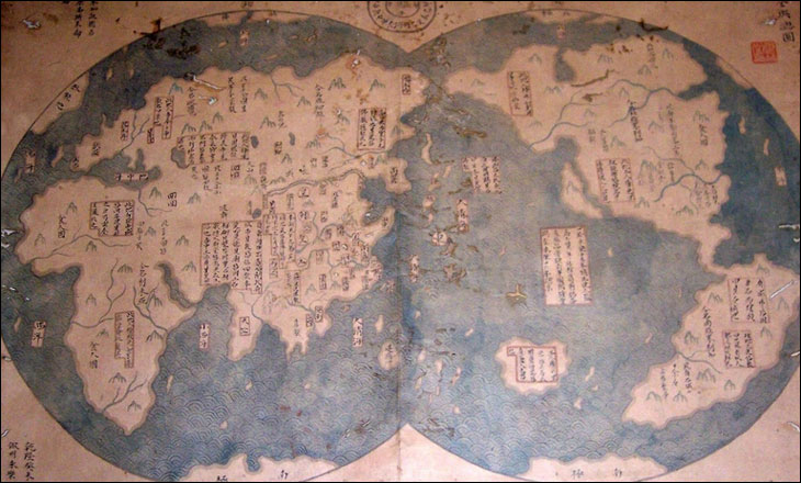
Menzies’ thesis won’t die. Just when it seemed to be fading out (unless Menzies’ argument about Mongol exploration is really his next focus), along comes this map (discussed in more depth here; update: and with translations of the notations here, and much more discussion by actual map historians here) which claims to be a 1763 copy of a 1418 map of the world. The Economist story even cites it as a possible source for previously unexplained pre-Columbian maps showing (something vaguely resembling) the Americas!
Geoff Wade at the National University of Singapore (who has challenged Menzies before) provided a quick rebuttal to the Economist article, so I don’t have to
The map is an 18th century copy of a European map, as evidenced by the two hemispheres depicted, the continents shown and the non-maritime detailed depicted. It proves nothing other than the Chinese (and Japanese) were copying European maps. That your writer has contributed to the Menzies’ bandwagon and its continuing deception of the public is saddening. The support mentioned all comes from Mr Menzies’ band of acolytes and the claims have no academic support whatsoever.
He goes into some detail on both the maps and “experts” cited, and I’m sure H-Asia will be abuzz for a while on this topic.
There are two things that I find interesting about this, on first look.
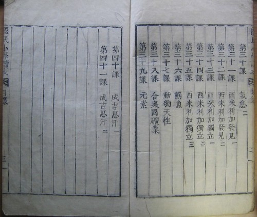
‘An Elementary Reader for Citizens’ (國民小學讀本)
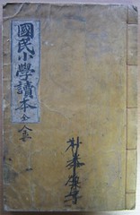
At my own blog I’ve been writing a series of posts about some interesting old Korean books I’ve come across in the library of the School of Oriental and African Studies. This is actually no. 5 in that series, but I thought that it would be worthwhile crossposting it here. A list of the previous entries in the series can be found at the bottom of this post.
The book in question is probably the first modern textbook produced in Korea. Entitled An Elementary Reader for Citizens (國民小學讀本), it was first published by the education ministry of the country that was then known as Tae Chosŏn’guk (‘Great Chosŏn Nation’) in 1895, or year 504 of the dynasty, if you use the short-lived dating system that was current at the time.
A facsimile edition was published in the 80s which still seems to be available at secondhand bookshops. It is certainly a book that I’d like to get around to looking at in greater detail. The first attempt at creating some sort of general, state-led educational material in Korea must have echoes that can be seen and felt even today, 111 years later. It is also fascinating to see what these early educationalists thought was important for the citizens of Chosŏn to know about. And some of the language used, even in the chapter headings, is interesting too, like the use of the word Chinaguk (支那國) for China instead of Chungguk (中國).
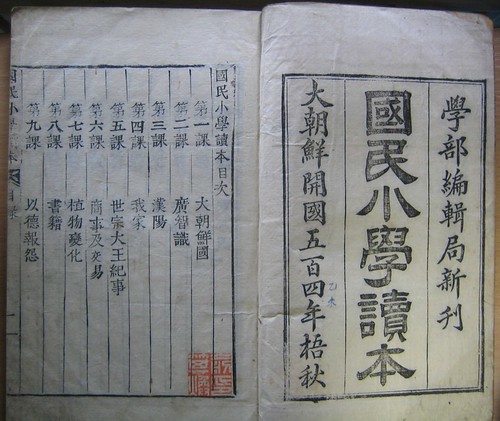
The title page and first page of contents.
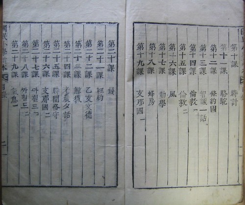
The book contains 41 lessons/readings in all, covering everything from the American War of Independence to camels. Here are the titles of the first 12 lessons:
Lesson 1: Great Chosŏn (大朝鮮國)
Lesson 2: General Knowledge (廣智識)
Lesson 3: Hanyang [Seoul] (漢陽)
Lesson 4: Our Family (我家)
Lesson 5: The Reign of King Sejong (世宗大王紀事)
Lesson 6: Commerce and Trade (商事及交易)
Lesson 7: The Transformation [evolution?] of Plants (植物變化)
Lesson 8: Books (書籍)
Lesson 9: Getting Revenge through Kindness (以德報怨)
Lesson 10: Clocks (時計)
Lesson 11: The Camel (駱駝)
Lesson 12: The Treaty Powers (條約國)
I think some of my translations probably leave something to be desired, so any suggestions or corrections would be welcome. Or perhaps you might like to translate some of the rest of the lesson titles. Here are the rest of the contents:
Korean books at SOAS, previous entries:
Part one
Part two
Part three
Part four
Par for the course…
I never thought I’d be citing Sports Illustrated here (Alan started it!) [via], but a Chinese historian has found references from over a thousand years ago to what he claims is the earliest known form of golf:
Professor Ling Hongling of Lanzhou University says he has uncovered evidence in a book called the Dongxuan Records that proves golf was played in China in AD 945.
The book, written during the Song Dynasty from AD 960 to AD 1279, claims the game was called chuiwan and was played with 10 different jewel-encrusted clubs, including a cuanbang — equivalent to a modern-day driver — and a shaobang — the ancient three-wood.
The term chui actually means “to hit” while wan is the term for a ball.
…
[H]e claims the game was imported to Europe by Mongol traders during the late Middle Ages.
…
[H]e claims a reference in the Dongxuan Records sees a prominent Chinese magistrate of the Nantang Dynasty (AD 937-975) instructing his daughter “to dig holes in the ground so that he might drive a ball into them with a purposely crafted stick.”
I was going to say “obviously, more research is needed” but then I realized that I really don’t care…. The evidence at the moment is decidedly thin — “smoking gun” traces rather than credible documentation — and there’ll be lots of heat back and forth with the Scottish, but it’s going to be a long time before there’s enough evidence to be worth revising the historical record. For one thing, is there any evidence that the Mongols played any such game or could have transmitted it any other way?
As the article says, “The Chinese have a history of making audacious claims to having invented sports,” not to mention everything else.